
Queulat National Park - Home of the Hanging Glacier
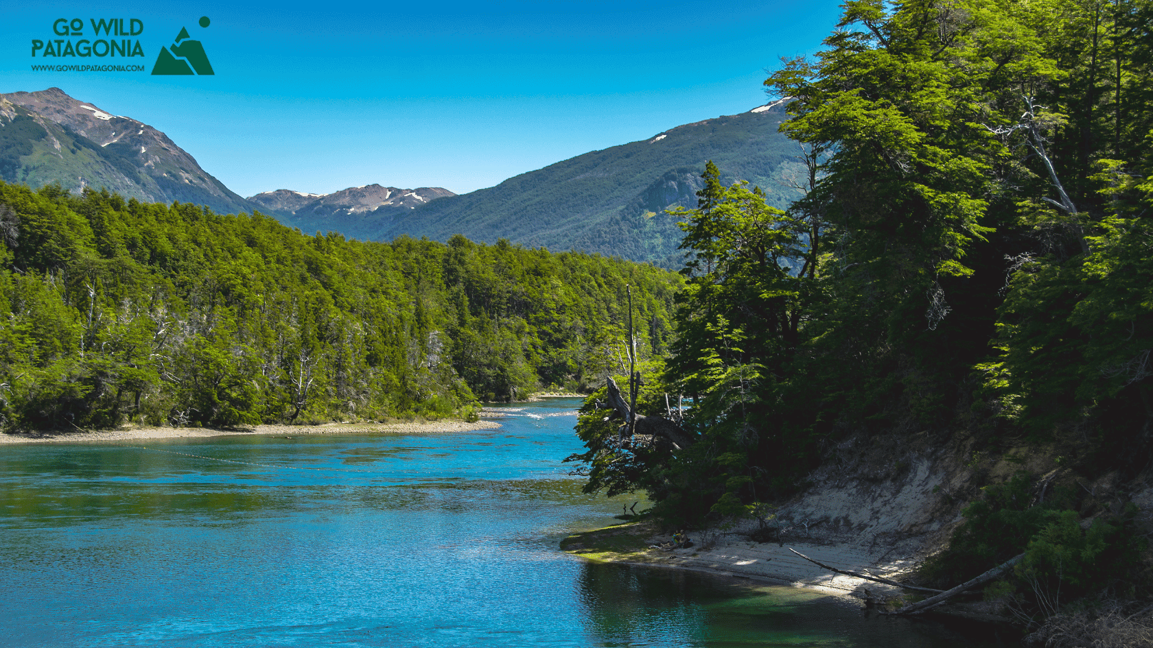
Queulat National Park protects 154,000 hectares of pristine temperate rainforest and dramatic glacial landscapes in Chilean Patagonia, centered on the spectacular Ventisquero Colgante (Hanging Glacier)—a glacier suspended on a cliff face that ranks among the Carretera Austral's most iconic sights.

Queulat National Park
Aysén Region, Chile — Home of the Hanging Glacier
Overview
Queulat National Park protects 154,000 hectares of pristine temperate rainforest and dramatic glacial landscapes in Chilean Patagonia, centered on the spectacular Ventisquero Colgante (Hanging Glacier)—a glacier suspended on a cliff face that ranks among the Carretera Austral's most iconic sights. Located 165 km north of Coyhaique, the park showcases the transition zone where temperate rainforest meets high Andean ice: moss-draped coihue and tepa trees, bamboo thickets (colihue), rushing rivers, and hanging glaciers descending from the Northern Ice Field. The Carretera Austral (Route 7) bisects the park, making access straightforward—most visitors stop for the short hike to Ventisquero Colgante viewpoint (3 km round trip), photograph the glacier calving into its lagoon, then continue their journey. But the park offers much more: Laguna Témpanos (iceberg lagoon), Bosque Encantado (enchanted forest trail), multi-day backcountry treks, and complete solitude beyond the hanging glacier area. It's raw, wet (4,000mm annual rainfall), and stunningly beautiful—Patagonia's temperate rainforest at its most dramatic.
Why Visit
Witness the Hanging Glacier — Ventisquero Colgante: glacier suspended 500m up a cliff face, ice chunks constantly calving into turquoise lagoon below. From viewpoint, watch/hear ice fall, mist rises, thunderous crashes echo. One of Chile's most photographed natural wonders.
Hike through enchanted rainforest — Dense temperate forest unlike anywhere else: trees draped in moss and lichen, ferns carpeting ground, bamboo creating green tunnels, rivers plunging over waterfalls. Mystical, primordial atmosphere.
Experience extreme rainfall — Queulat receives 4,000mm (157 inches) annual rainfall—among Chile's wettest. This creates the lush scenery but also requires embracing perpetual damp. Horizontal rain, mist, dripping forests—it's beautiful if you accept it.
Camp in pristine wilderness — Basic campgrounds within park offer platform sites amid rainforest. Fall asleep to river sounds, wake to bird calls, experience pure nature.
Explore beyond the crowds — While hanging glacier draws visitors, other park areas remain nearly empty. Laguna Témpanos, backcountry trails, remote valleys see handful of people annually.
Photograph dramatic landscapes — Misty forests, glacier calving, turquoise lagoons, waterfalls, moody weather—photographer's dream. Overcast days (frequent!) actually work better than harsh sun.
Getting There
By Car (Best Option): Carretera Austral (Route 7) runs through park. From Coyhaique: 165 km north (3-3.5 hrs). Well-maintained gravel. From Puyuhuapi: 45 km south (45 min). Park Entrances: Main entrance/ranger station at park center (Ventisquero Colgante trailhead area). Parking: Ample near hanging glacier trailhead, campgrounds. Road: Carretera traverses park—40 km section. Can drive through without stopping (though why would you?).
By Bus: Carretera Austral route buses pass through. From Coyhaique: 2-3x weekly (~$15-20), ask driver to drop at park entrance. From Puyuhuapi: Same buses northbound. Challenge: Buses don't wait—must be roadside when scheduled. Return: Flag bus from road (uncertain—could wait hours). Recommendation: Only viable for multi-day park stays with camping gear. Day trips difficult without car.
By Tour: Puyuhuapi and Coyhaique tour operators offer day trips (~$80-120 per person including transport, guide, lunch). Convenient but expensive.
Hitchhiking: Possible summer—Carretera Austral tourist traffic. Stand at park entrance sign. Can wait 30 min to 2+ hours. Bring tent, food.
Important: No services inside park—no stores, no gas, no restaurants. Bring all supplies. Ranger station has basic info, toilets. Camping only accommodation. Nearest towns: Puyuhuapi (45 km north), Villa Amengual (55 km south, tiny).
Top Experiences
Ventisquero Colgante (Hanging Glacier) Hike — The must-do. Trailhead: Main parking area off Carretera Austral. Distance: 3 km round trip. Time: 1.5-2 hours total (easy pace with photo stops). Difficulty: Easy—boardwalk sections, some steps, well-maintained. Route: Ascends gradually through dense rainforest (coihue, tepa, ferns, moss everywhere), crosses suspension bridge over Río Ventisquero, reaches lagoon viewpoint. The Glacier: Hangs on cliff 500m above lagoon, 100m+ ice face visible. Ice constantly calves—watch chunks fall, crash into turquoise water, create waves. Hear thunderous booms echoing. Mist rises from impacts. Photography: Multiple viewpoints along trail. Boardwalk at lagoon edge best position. Overcast actually better than harsh sun (reduces glare, enhances blue tones). Best Time: Morning (fewer people), though glacier calves throughout day. Crowds: Popular—50-100 people daily summer (still spacious—you'll get alone moments). Essential: This is why Carretera Austral travelers stop. Budget minimum 2 hours with hike and glacier observation.
Laguna Témpanos (Iceberg Lagoon) — More remote glacier experience. Location: Separate sector, 22 km north of main entrance via spur road off Carretera. Drive: Rough gravel road (slow—45 min). Hike: 3.5 km round trip (2 hrs) to lagoon viewpoint. Steeper than hanging glacier trail—moderate difficulty. Lagoon: Icebergs float in turquoise water, calved from glacier at valley head. Fewer visitors—maybe 10-20 people daily (vs. 100 at hanging glacier). Quieter, wilder feeling. Can camp near trailhead (basic sites). Best: If you have time for two glacier experiences, this adds different perspective. Reality: Most skip due to rough access road and hanging glacier being more spectacular.
Bosque Encantado (Enchanted Forest) Trail — Misty forest immersion. Location: Near Laguna Témpanos area. Trail: Short loop (1.5 km, 45 min) through dense old-growth forest. Features: Moss-covered trees, twisted trunks, ferns, bamboo, atmospheric even by Queulat standards. Best: Foggy/drizzly days (most days!)—mist through trees creates eerie beauty. Photography: Wide angle, tripod useful (low light), embrace mood. Solitude: Very few hike this—you'll likely be alone.
Río Padre García Waterfall — Roadside cascade. Location: Along Carretera Austral within park (before main entrance coming from south). Access: Pull off road, short walk (5 min) to viewpoint. Waterfall: Drops 30+ meters into gorge. Powerful, impressive. Timing: Quick stop (15-20 min) en route to/from hanging glacier. Photography: Good from multiple angles. Free, easy.
Camping at Ventisquero — Overnight in park. Campground: Near hanging glacier trailhead—platform sites, pit toilets, covered shelters, river access. Cost: ~$15-20 per site. Capacity: ~15 sites. First-come: No reservations (rarely full except mid-January). Experience: Fall asleep to river roar, rain on tent (likely!), wake to birds, morning hike to glacier before crowds. Facilities: Basic—bring full self-sufficient gear. Best: If doing multi-day exploration or want dawn glacier visit.
Sendero Río de las Cascadas — Longer waterfall hike. Stats: 6 km round trip (3-4 hrs), moderate. Route: Follows river upstream, multiple small waterfalls, ends at larger cascade. Trailhead: Near main entrance. Less visited: Maybe 5-10 people daily. Best: If spending full day, combines with hanging glacier. Condition: Muddy (always), slippery roots, sturdy boots essential.
Wildlife Watching — Temperate rainforest fauna. Birds: Chucao tapaculo (distinctive call—sounds like someone chopping wood), Magellanic woodpecker (huge, spectacular red head), hummingbirds, parakeets. Mammals: Pudú (miniature deer—rare, dawn/dusk), foxes, river otters. Best: Early morning trails, patient observation, quiet. Bring: Binoculars, field guide. Reality: Forest dense—hearing wildlife easier than seeing.
Photography Workshop Opportunities — Moody conditions ideal. Subjects: Misty forests, glacier calving (catch ice falling—requires patience/luck), waterfalls, macro (moss, ferns, lichen). Best: Overcast days (reduce contrast), morning mist, post-rain (everything glistens). Gear: Wide angle for landscapes, macro for forest details, tripod essential (low light), rain covers crucial.
Multi-Day Backcountry Trek — For experienced. Routes: Various trails into park interior—remote valleys, glacier approaches, high passes. Difficulty: Expert navigation required (trails faint/nonexistent), river crossings, heavy rain, no facilities. Register: Mandatory with rangers before departing. Season: January-March only (snow other months). For: Self-sufficient wilderness experts seeking extreme solitude.
Fishing Río Queulat & Tributaries — Trout in park waters. Species: Brown and rainbow trout. Access: Rivers along trails, road access points. Regulations: Catch-and-release, check with rangers. Season: November-April. Licenses: Required (purchase Coyhaique or Puyuhuapi). Pressure: Minimal—you'll fish alone. Quality: Good but challenging (dense vegetation, cold water).
Where to Stay
Inside Park:
Camping Ventisquero: Near hanging glacier trailhead. Platform sites, pit toilets, covered shelters (~$15-20 per site). First-come basis.
Camping Angostura (near southern entrance): Similar facilities (~$15-20).
Backcountry camping: Free but register with rangers. No facilities.
Outside Park:
Puyuhuapi (45 km north): Hospedajes, hotels, hot springs (see Puyuhuapi guide). Most base here for day trip. (~$40-180 depending on option).
Villa Amengual (55 km south): Tiny village, very basic hospedajes (~$30-50). Emergency option only.
Coyhaique (165 km south): Full range accommodations. Long day trip to Queulat possible but rushed (~$40-150+).
Reality: Most Carretera Austral travelers either: (1) day trip from Puyuhuapi, (2) quick stop while passing through, or (3) camp one night at Ventisquero.
Best Time to Visit
December-February (Summer): Least rainfall (relatively—still wet!), warmest temps (12-18°C days, 5-10°C nights), longest daylight (5 AM-10 PM), best trail conditions (least mud—still muddy), most visitors (100 people daily at hanging glacier—still quiet). Glacier calving most active (warm temps). All trails accessible. Camping comfortable (relatively—still damp/cold). Best overall for first-timers, photography, easy logistics.
March-April (Autumn): Cooler (10-15°C), increasing rainfall, shorter days. Fewer visitors (maybe 20-30 daily). Autumn colors limited (mostly evergreens). Trails increasingly muddy. Camping cold/wet. March viable for hardy; April marginal. Good for photographers (moody conditions, dramatic light).
October-November (Spring): Heavy rain, cold (8-12°C), snow lingers high trails. Services gradually reopening. Very few visitors. Wildflowers late October onwards. Late November approaching summer. For extreme adventurers accepting harsh conditions.
May-September (Winter): Off-season. Extremely wet (torrential rain), cold (5-10°C days, below freezing nights), deep snow on trails, short days (9 AM-6 PM light). Camping impractical (everything soaked). Hanging glacier accessible roadside but trail icy/dangerous. Rangers may close trails. Only for through-travelers on Carretera Austral (glance from road) or extreme masochists.
Rainfall Reality: Queulat receives 4,000mm (157 inches) annual rainfall. For comparison: Seattle gets 940mm, London 690mm. Even "dry" summer months average 200-300mm monthly. Expect rain ALWAYS. Multiple days of sun per year (literally—maybe 10-15 clear days annually). Horizontal rain common (wind-driven). Everything perpetually wet—trails muddy, trees dripping, rivers flooding. Pack accordingly: waterproof jacket/pants, waterproof bags, quick-dry clothes, embrace dampness. This wetness creates the stunning rainforest—trade-off accepted.
Sample Itineraries
Half-Day Visit (Typical)
9-10 AM: Arrive from Puyuhuapi or Coyhaique 10 AM-12 PM: Hanging glacier trail hike (3 km, 1.5 hrs) + observation time at lagoon (30-60 min watching calving) 12-12:30 PM: Quick stop Río Padre García waterfall 12:30 PM: Depart continuing Carretera Austral
Reality: Most travelers do this—quick stop while transiting. Sees the icon, moves on.
Full-Day Visit
Morning:
9 AM: Arrive, hanging glacier hike (2 hrs including photo time)
11 AM: Return to parking, drive to Laguna Témpanos sector (45 min)
Midday:
Laguna Témpanos hike (3.5 km, 2 hrs)
Lunch at trailhead (bring food)
Bosque Encantado trail (45 min)
Afternoon:
Return main park area
Sendero Río de las Cascadas hike (3-4 hrs) OR relax at campground
5-6 PM: Depart or camp overnight
2-Day Itinerary (Thorough Exploration)
Day 1:
Morning: Arrive, set up camp at Ventisquero campground
Midday: Hanging glacier hike (take time—multiple viewpoints, wait for calving)
Afternoon: Sendero Río de las Cascadas waterfall hike
Evening: Camp dinner, rain on tent (likely), early sleep
Day 2:
Early: Second hanging glacier visit (dawn light, zero crowds)
9 AM: Pack camp, drive to Laguna Témpanos
Midday: Témpanos hike + Bosque Encantado
Afternoon: Depart for next destination
Alternative Day 2: Fishing, wildlife observation, photography focus, relaxed pace
Where to Go Next
1. Puyuhuapi — Hot Springs Village (45 km north, 45 min)
Transport: Drive or bus northbound
Why Go: Rest aching muscles at Termas Ventisquero luxury hot springs resort. After cold/wet Queulat, volcanic thermal pools feel like paradise. German-founded village, good hospedajes, fjord kayaking. Budget 1-3 days.
2. Coyhaique — Regional Capital (165 km south, 3-3.5 hrs)
Transport: Drive or bus southbound (~$15-20)
Why Go: Aysén region main city—resupply, restaurants, comfortable hotels, ATMs. Gateway to Laguna San Rafael glacier boat trips. Continue south on Carretera Austral toward Cerro Castillo (trekking), Marble Caves, Cochrane, Villa O'Higgins. Budget 2-3 days Coyhaique; 7-14 days southern Carretera highlights.
3. Chaitén — Volcano Town (255 km north, 5-6 hrs via Puyuhuapi)
Transport: Drive or bus northbound
Why Go: Town rebuilt after 2008 eruption, ash-covered beaches, gateway to Pumalín Park (ancient alerces 60 km north), Futaleufú rafting (150 km east). Continue north on Carretera Austral eventually to Puerto Montt. Budget 1-2 days Chaitén; 3-5 days Pumalín; 5-7 days Futaleufú if detouring.
4. Futaleufú — Whitewater Mecca (detour east from Villa Santa Lucía junction, 200 km from Queulat)
Transport: Drive—requires backtracking north from Queulat to junction, then east to Futaleufú
Why Go: World-class whitewater rafting, kayaking. Multi-day river expeditions on turquoise Class IV-V rapids. Complete contrast to wet forests—adventure adrenaline. Budget 3-7 days.
Planning Your Routes:
Classic Carretera Austral: Puerto Montt → Pumalín → Chaitén → Puyuhuapi (2 days rest) → Queulat (half-day) → Coyhaique (2 days) → Marble Caves → Cochrane → Villa O'Higgins. Total: 14-21 days.
Northern Carretera Focus: Puerto Montt → Pumalín (3 days) → Futaleufú detour (5 days) → return Chaitén → Puyuhuapi (2 days) → Queulat → Coyhaique → fly out. Total: 12-15 days.
Quick Glacier Fix: Fly Coyhaique → drive north to Queulat (half-day hanging glacier) → Puyuhuapi hot springs (overnight) → return Coyhaique → fly out. Total: 3-4 days.
Timing Tips:
Budget half-day minimum for hanging glacier; full-day for thorough park exploration
Most combine Queulat with Puyuhuapi hot springs (logical pairing—same region)
December-February best weather (still wet!) and trail conditions
Arrive early morning (9-10 AM) to beat crowds at hanging glacier
Bring FULL waterproofs—rain guaranteed regardless of forecast
Camp overnight only if comfortable with wet/cold conditions
Laguna Témpanos worth it if time allows—fewer people, different experience
Photography best overcast days (frequent!)—embrace mood not sun
Don't rush—hanging glacier rewards time (watching calving, various viewpoints)
Essential Carretera Austral stop—don't skip even if weather poor
Embrace rain—it creates the stunning scenery you came to see
Final Thoughts:
Queulat challenges visitors: perpetual rain, muddy trails, cold, damp gear. But those who embrace these conditions discover something remarkable—temperate rainforest in its purest form, a glacier defying gravity by hanging on a cliff, and landscapes so primordial they feel Jurassic.
The hanging glacier alone justifies stopping. That ice suspended 500 meters up, calving chunks that thunder into the lagoon—it's visceral, powerful, humbling. Few places let you witness glacial processes so intimately, so accessibly.
Beyond the glacier, Queulat remains largely unexplored. While crowds (relatively speaking) gather at Ventisquero Colgante, other valleys stay empty. For those willing to venture deeper, the park offers true wilderness—the kind where you're more likely to see pudú than people.
Pack waterproofs. Expect rain. Embrace dampness. And when that glacier calves, when ice crashes into turquoise water and mist rises through the rainforest—you'll understand why Carretera Austral travelers call Queulat unmissable.
About Me
Veb
Hey there! I’m Veb and I've traveled solo and in groups for 10+ years in Patagonia - across Chile and Argentina.
I started Go Wild Patagonia with a desire to help other travelers plan their journeys in Patagonia with a focus on adventure, nature and being in the wilderness.
Say Thanks
Support my mission to make Patagonia more accessible for travelers while supporting local tour operators who organize only sustainable travels in Patagonia.
Read More
Chubut Province, Argentina — Cathedral of Ancient Trees Overview Los Alerces National Park protects 263,000 hectares of pristine Valdivian rainforest in Argentine Patagonia, home to some of the oldest living trees on Earth. The park's namesake—the alerce tree (Fitzroya cupressoides)—can live over 3,000 years, rivaling California's sequoias and bristlecone pines.
Update on Oct 24, 2025

El Bolsón offers world-class hiking: Refugio Hielo Azul and Refugio Cajón del Azul sit in alpine cirques accessible via multi-day treks, Cerro Piltriquitrón (2,284m) provides panoramic summit views, and Cajón del Azul's turquoise canyon ranks among Patagonia's most photographed day hikes.
Update on Oct 24, 2025

Monte Leon National Park is Argentina's first coastal national park, protecting 40 km of dramatic Atlantic shoreline where the Patagonian steppe meets the sea.
Update on Oct 24, 2025
