
Puerto Rio Tranquilo - Gateway to the Marble Caves
Gateway to the Marble Caves Overview Puerto Río Tranquilo is a small village of 300 on the shores of Lago General Carrera (Chile's largest lake, shared with Argentina where it's called Lago Buenos Aires), serving as gateway to the famous Capillas de Mármol—the stunning blue-and-white marble caves that rank among Chile's most photographed natural wonders.

Puerto Río Tranquilo
Aysén Region, Chile — Gateway to the Marble Caves
Overview
Puerto Río Tranquilo is a small village of 300 on the shores of Lago General Carrera (Chile's largest lake, shared with Argentina where it's called Lago Buenos Aires), serving as gateway to the famous Capillas de Mármol—the stunning blue-and-white marble caves that rank among Chile's most photographed natural wonders. Located 223 km south of Coyhaique on the Carretera Austral, this unassuming settlement comes alive with tourists during summer months (December-March) who arrive specifically to boat into the swirled marble formations carved by millennia of wave erosion. The village itself is simple—a handful of hospedajes, basic restaurants, small grocery stores—but the setting is spectacular: turquoise lake stretching to distant mountains, roadside glaciers visible, and those impossible marble caves glowing blue just offshore. Beyond the caves, the area offers glacier explorations (Exploradores Glacier 50 km south), lake kayaking, fishing, and serves as midpoint stop on the Carretera Austral journey. It's functional tourism at its most straightforward: people come for one reason (marble caves), stay 1-2 nights, then continue their journey. But that one reason is truly spectacular.
Why Visit
Marvel at the Marble Caves — Capillas de Mármol: blue-and-white swirled marble formations creating cathedral-like caves. Centuries of waves carved intricate patterns into solid marble cliffs. On sunny days with calm water, the blue glows electric—utterly surreal, unlike anything else on Earth.
Kayak among marble formations — Small boats and kayaks navigate tight passages between marble walls, allowing intimate exploration. Paddle into chambers, touch ancient stone, photograph from water level.
Access Exploradores Glacier — 50 km south via rough road: massive glacier descending from Northern Ice Field. Hike to blue ice face, witness seracs (ice towers) and crevasses. Less visited than famous glaciers but equally impressive.
Base for Lago General Carrera activities — Chile's largest lake (1,850 km²): kayaking, fishing, beach camping, island exploration. Massive body of turquoise water with numerous access points.
Stopover on Carretera Austral — Logical midpoint between Coyhaique (north) and Cochrane (south). Break the journey, experience highlight, continue refreshed.
Photograph endlessly — The marble caves are photographer's dream: changing light throughout day creates different moods, water reflections, blue tones, natural sculptures. Can spend hours shooting.
Getting There
By Bus: Regular Carretera Austral route services. From Coyhaique: 223 km south (4-5 hrs, $25-30, 3-4x weekly). Companies: Buses Acuario, Don Carlos. From Cochrane: 130 km north (2.5 hrs, $15-20). Schedule: Summer (Dec-Mar) more frequent; winter reduced. Book: 1-2 days ahead peak season; day-of usually fine otherwise. Stops: Buses stop at Puerto Tranquilo main junction—short walk to lake shore accommodations.
By Car: Self-drive ideal for flexibility and accessing Exploradores Glacier. From Coyhaique: 223 km south on Carretera Austral (Route 7). Well-maintained gravel, scenic. Pass Cerro Castillo (hiking), continue lakeside. 4-5 hours. From Cochrane: 130 km north. 2.5 hours. From Chile Chico: 130 km west via lakeside lateral road. 3-4 hours (slower—narrower road). Parking: Plenty near lake shore. High clearance helpful but not essential.
Hitchhiking: Viable summer—decent tourist traffic on Carretera Austral. Stand at junction. Spanish helpful. Bring tent (waits possible). Traffic drops significantly winter.
Important: Small village—arrive with cash (ATM unreliable), camping gear if budget traveling, food supplies if picky (basic restaurants only).
Top Experiences
Capillas de Mármol (Marble Caves) Boat Tours — THE reason people visit. Formations: Solid marble cliffs eroded by wave action over thousands of years into cathedral-like caves, arches, tunnels. Blue-and-white marbling creates swirled patterns. Color: On sunny days with calm water, the blue is electric—light reflects off turquoise water onto white marble ceilings, creating ethereal glow. Tours: Small motor boats (6-8 passengers) depart from Puerto Tranquilo shore. Duration: 45 min to 1.5 hrs depending on tour length. Short tour (~45 min) visits main cathedral; longer extends to additional formations. Cost: ~$15-20 USD per person (remarkably cheap for what you get). Operators: Multiple companies at waterfront—similar prices, similar routes. Depart when boats fill (frequent in summer). Best conditions: Sunny days (blue pops), calm water (enter caves safely—rough water prevents cave access). Morning usually calmest. Season: Year-round but summer (Dec-Feb) best weather and most reliable. Photography: Bring waterproof camera/housing—spray common. Wide angle lens ideal. Polarizing filter helps. Must do—this is why you're here.
Kayaking the Marble Caves — More intimate exploration. Advantages: Navigate tighter passages, control your pace, photograph from unique angles, feel marble texture. Rentals: Available from tour operators (~$40-50 USD for 2-3 hours including guide). Difficulty: Beginner-friendly in calm conditions. Guides lead groups. Best: Morning when lake calm—wind picks up afternoon. Safety: Cold water (10-12°C)—wetsuits or dry clothing essential. Photography: Easier from kayak (stable, hands-free moments). Alternative: Stand-up paddleboard tours offered (~$35-40). Season: Dec-March optimal.
Exploradores Glacier Excursion — Spectacular but requires effort. Location: 50 km south of Puerto Tranquilo via rough gravel road (2 hrs drive). Access: Need car (4WD helpful but not essential if dry), or arrange tour/taxi (~$100-150 round trip for vehicle). Hike: From parking area, 1-2 hr hike to glacier face (depending on route—glacier retreating so distance increases). Glacier: Massive blue ice wall descending from Northern Ice Field. Crevasses, seracs (ice towers), intense blue color. Can approach very close—feel cold air, hear groaning ice. Photography: Stunning. Hazard: Stay back from face (calving risk). Duration: Half-day minimum from Puerto Tranquilo; full-day comfortable. Best: December-February (access road best). Alternative: Ice trekking tours with crampons offered by specialists (arrange in advance, ~$150-200). Worth effort—far less crowded than San Rafael or Perito Moreno.
Lago General Carrera Kayaking — Explore massive lake beyond caves. Options: Multi-day kayak camping along shoreline, island visits, remote beach access. Rentals: Limited—tour operators may arrange. Better bring own packraft/kayak. Challenges: Large lake, wind can be fierce, cold water. Only for experienced paddlers. Rewards: Solitude, pristine campsites, different marble formations along shore. Best: January-February (calmest). Multi-day: 3-7 day circuits possible for advanced.
Capilla de Mármol Viewpoint (Land-Based) — Free alternative if budget-tight or weather prevents boats. Location: Small marble outcrop accessible by short walk from town. Views: Not the main caves but gives sense of marble formations. Photography: Decent shots from shore. Reality: Boat tours so affordable (~$15) and spectacular, this is poor substitute. But free.
Fishing Lago General Carrera — Trophy trout in massive lake. Species: Brown trout, rainbow trout, some salmon. Techniques: Shore casting or trolling from boat. Hot spots: River mouths, rocky points. DIY: Possible from shore. Boat access better. Guides: Limited locally—ask at hospedajes. Season: November-April. Licenses: Purchase in Puerto Tranquilo small shop or Coyhaique. Solitude: High—lake massive, few anglers.
Glaciar Leones Trek — Multi-day backpacking option. Distance: ~40 km round trip. Duration: 3-4 days. Route: From southern lake shore (requires transport to trailhead), trek through valleys to Leones Glacier. Camping: Wild camping en route. Difficulty: Moderate-strenuous, river crossings, navigation required. Solitude: Extreme. Register: With carabineros before departing. For: Experienced backpackers seeking serious wilderness. Season: January-February only.
Beach Camping & Lake Sunsets — Free camping on lake shores. Spots: Multiple beaches around Puerto Tranquilo area—pull off road, camp on sand/gravel. Views: Turquoise water, mountains, marble cliffs. Sunsets: Beautiful—alpenglow on peaks across lake. Facilities: None—bring self-sufficient gear. Allowed: Generally yes, but ask at property if near houses. Popular: Backpackers and overlanders love this—free, scenic.
Cerro Castillo Day Trip — From Puerto Tranquilo, Cerro Castillo trailhead 100 km north (toward Coyhaique). Option: Day trip to hike Laguna Cerro Castillo (16 km, 8 hrs, stunning turquoise lake below jagged peaks). Or: Multi-day Cerro Castillo Circuit (4 days). Requires: Car or arrange transport. Worthwhile: One of Aysén's best treks. Combine: With Puerto Tranquilo stop on Carretera Austral journey.
Where to Stay
Budget:
Camping: Multiple basic campgrounds near lake shore (~$8-12 per person). Simple facilities.
Wild camping: Free on beaches outside town (self-sufficient).
Hospedaje Residencial: Simple family homes renting rooms (~$25-40 per person with breakfast). Ask at village center.
Mid-Range:
El Puesto Expediciones: Hostel/hotel mix, comfortable, tour desk (~$60-90 privates)
Hostería Costanera: Lake views, decent rooms (~$70-100)
Cabañas Marble Caves: Self-catering cabins (~$80-120 per cabin)
Upscale (relative to village):
Hacienda Tres Lagos: Best option, outside town, estancia-style (~$120-180 with meals)
Mallin Colorado Ecolodge: Eco-lodge with tours, comfortable (~$150-220 with meals and activities)
Limited Options: This is tiny village. January book 1-2 weeks ahead. Rest of year usually walk-ins fine. Camping always available.
Best Time to Visit
December-February (Summer Peak): Best weather (15-22°C days, 5-10°C nights), calmest lake conditions, most reliable marble cave tours (calm water essential for cave entry). Longest daylight (5 AM-10 PM). All services open. Most tourists (still not overwhelming—maybe 50-100 people at village peak times). Blue of caves most electric on sunny days—common in summer. Exploradores Glacier road best condition. Ideal overall. January busiest (Chilean summer vacation). Book 1-2 weeks ahead. Best months: January-February for stable weather and blue water.
March-April (Autumn): Shoulder season. Fewer tourists, autumn colors (limited—mostly grasslands), comfortable temps (10-18°C). Lake still accessible for tours but conditions less reliable—wind picks up, cloudy days reduce blue effect. Exploradores road may deteriorate with autumn rains. Some services close April. Prices drop. March viable; April marginal. Good for budget travelers accepting variability.
October-November (Spring): Spring conditions. October still cold (5-12°C), unpredictable. November improves—wildflowers, warming. Marble tours resume (weather permitting) but winds common. Exploradores glacier access may have snow/mud issues. Services gradually reopen. Very few tourists. Late November approaches summer. For pioneers comfortable with uncertainty.
May-September (Winter): Off-season. Cold (0-10°C days, below freezing nights), short days, heavy precipitation. Marble tours sporadic—lake often too rough. Exploradores road may be impassable (snow, mud). Most tourism services close. Very few visitors. Only for Carretera Austral through-travelers or extreme off-season adventurers. Blue of caves less impressive without sun—gray/dull. Not recommended unless transiting through.
Weather Reality: Even summer, weather changes fast. Morning can be sunny/calm (perfect caves), afternoon windy/cloudy (tours cancel). Build flexibility—plan 2 days to ensure getting on water.
Sample Itineraries
1-Day Itinerary (Quick Stop)
Morning:
Arrive from Coyhaique or Cochrane
Drop bags at hospedaje
10-11 AM: Marble caves boat tour (1-1.5 hrs)
Photograph, marvel, absorb
Afternoon:
Lunch: Simple restaurant (trout, lamb, soup)
Walk lake shore, viewpoints
OR: Short kayak rental (2 hrs)
4-5 PM: Depart for next destination (Cochrane south or Coyhaique north)
Realistic: Many travelers do this—marble caves main/only attraction, see it, move on.
2-Day Itinerary (Recommended Minimum)
Day 1:
Morning: Arrive, check in
Midday: Marble caves boat tour (timing depends on light/conditions—ask locals for best time)
Afternoon: Kayak rental for closer exploration, or relax at lake shore
Evening: Sunset from beach, simple dinner
Night: Hospedaje or camp
Day 2:
Full day: Exploradores Glacier excursion
Drive south (2 hrs), hike to glacier, explore
Return afternoon
OR (if no car): Second marble caves visit different time of day (light changes), fishing, relaxation
Evening: Depart or overnight again
3-Day Itinerary (Complete Area Exploration)
Day 1: Arrive, settle, marble caves boat tour, sunset
Day 2: Full-day Exploradores Glacier (drive, hike, photography, return)
Day 3: Morning kayaking marble formations (2-3 hrs), afternoon fishing or beach time, evening depart
Alternative Day 3: Drive to Cerro Castillo (100 km north), day hike Laguna Cerro Castillo, return evening or continue north
Where to Go Next
1. Coyhaique — Regional Capital (223 km north, 4-5 hours)
Transport: Bus 3-4x weekly (~$25-30), or drive north on Carretera Austral
Why Go: Resupply hub, restaurants, hotels, services. From Coyhaique: access Laguna San Rafael (glacier boat trips—expensive but spectacular), Cerro Castillo (trekking), Simpson River Reserve. Also transportation hub—fly to Santiago or Puerto Montt. Or continue north on Carretera Austral toward Queulat (hanging glacier), Puyuhuapi (hot springs), Pumalín Park. Completes northern Carretera Austral journey. Budget 2-3 days Coyhaique itself; 7-14 days for northern Carretera highlights.
Suggested Duration: 2-3 days Coyhaique; 7-14 days northern Carretera Austral.
2. Cochrane — Southern Gateway (130 km south, 2.5 hours)
Transport: Bus 3-4x weekly (~$15-20), or drive south
Why Go: Continue south on Carretera Austral. Cochrane: working town (3,000), rafting Río Baker (Chile's largest river—turquoise), access to Patagonia National Park (90 km north of Cochrane—rewilded grasslands, guanacos, pumas), Caleta Tortel (stilted village 100 km south), Villa O'Higgins (road's end, 230 km south). Budget 1-2 days Cochrane; 5-10 days for southern Carretera explorations.
Suggested Duration: 1-2 days Cochrane; 5-10 days southern Carretera Austral.
3. Chile Chico — Border Town (130 km east, 3-4 hours)
Transport: Bus less frequent (~$20-25), or drive via lakeside lateral road
Why Go: Microclimate oasis (cherries! in Patagonia), border crossing to Argentina (Los Antiguos 8 km), access to Cueva de las Manos (Argentine rock art 130 km via Argentina). Creates binational route option: Puerto Tranquilo → Chile Chico → Argentina → Ruta 40 south to El Chaltén/El Calafate. Or just visit for cherry harvest (late Dec-Jan) and relaxed border town atmosphere. Budget 1-2 days.
Suggested Duration: 1-2 days Chile Chico; or use as connection point.
4. Complete Carretera Austral Journey
Why Go: Puerto Tranquilo sits roughly midpoint on 1,240 km Carretera Austral (Puerto Montt to Villa O'Higgins). Logical stopover when driving/busing the complete route. North from here: Cerro Castillo trekking, Coyhaique resupply, Queulat Hanging Glacier, Puyuhuapi hot springs, Chaitén volcano area, Pumalín ancient forests, ferry to Puerto Montt. South from here: Cochrane, Baker River rafting, Patagonia Park, Caleta Tortel boardwalk village, Villa O'Higgins road's end. Complete journey: One of world's great road trips—budget 14-21 days for highlights, 21-30 days for thorough exploration.
Suggested Duration: 14-30 days for complete Carretera Austral, depending on depth.
Planning Your Routes:
Classic Carretera Austral: Puerto Montt → ferry → Pumalín (3 days) → Chaitén → Puyuhuapi/Queulat (2 days) → Coyhaique (2 days) → Puerto Tranquilo (2 days marble caves) → Cochrane (2 days) → Caleta Tortel (1 day) → Villa O'Higgins (2 days) → return north or cross Argentina. Total: 14-21 days.
Marble Caves Focus Trip: Fly Santiago → Coyhaique → drive/bus south to Puerto Tranquilo (2 days marble caves + Exploradores) → return Coyhaique → fly Santiago. Total: 5-7 days. Quick trip specifically for caves.
Binational Loop: Puerto Tranquilo → Chile Chico → cross to Argentina → Ruta 40 south → El Chaltén (5 days trekking) → El Calafate (3 days glacier) → Torres del Paine Chile (7 days) → Punta Arenas. Total: 21-28 days.
Budget Backpacker Route: Bus Coyhaique → Puerto Tranquilo (2 days, camp free beaches, marble caves) → bus Cochrane → bus Villa O'Higgins → Argentina border crossing → El Chaltén. Minimal accommodations, camping, budget activities.
Timing Tips:
Puerto Tranquilo best as 1-2 night stopover, not multi-day destination
Visit December-February for best marble cave conditions (sunny, calm water)
Morning typically calmest for boat tours—schedule accordingly
Build 2 days if possible to ensure getting on water (weather backup)
Marble caves are the attraction—everything else is secondary
January busiest—book ahead; rest of year walk-ins usually fine
Exploradores Glacier requires vehicle or expensive taxi—factor into planning
Combine with Cerro Castillo for excellent Carretera Austral highlights pairing
Don't skip this—marble caves genuinely spectacular, unlike anywhere else
Photography best sunny days—check weather forecast, be flexible
Budget travelers: free beach camping + cheap boat tours = affordable highlight
Village tiny, services basic—arrive with supplies, cash, realistic expectations
Adventure Activities (Detailed)
Photography Tips for Marble Caves:
Best time: Morning 9-11 AM (sun angle, calm water) or late afternoon (golden hour, though water may be rougher)
Conditions: Sunny days essential—blue only pops with sunlight. Overcast creates gray/dull tones.
Equipment: Wide-angle lens (16-35mm) for cave interiors, medium (24-70mm) for details. Polarizing filter reduces glare, enhances blue. Waterproof housing or dry bag essential—spray inevitable.
Settings: Higher ISO (800-1600) inside dark caves. Bring tripod if doing long exposures (coordinate with boat driver to stabilize).
Composition: Include kayakers/boats for scale. Cave openings frame distant mountains beautifully. Reflections in calm water double the impact.
Video: Go-Pro or action cam ideal for POV footage navigating caves. Stabilization important.
Kayaking Safety:
Water temperature 10-12°C year-round—hypothermia risk real if capsizing
Wear proper clothing: wetsuit (provided by tours) or dry layers
Stay with guide group—wind can pick up suddenly
Morning paddle recommended (afternoon wind)
Know basic self-rescue or stay in guided groups
Lake is massive—respect its power
Exploradores Glacier Access (Detailed):
Road condition: 50 km gravel from Puerto Tranquilo—rough, washboard sections, river crossings. 2 hours driving. High clearance helpful; 4WD better but 2WD manageable when dry.
Navigation: Follow signs toward Bahía Exploradores. Road mostly obvious but GPS helpful.
Parking: Small area at trailhead—arrive early peak season (limited space).
Hike: Distance varies (glacier retreating)—currently ~3-4 km from parking to face. Muddy trail through forest, then moraine scrambling. Allow 3-4 hours round trip.
Glacier: Massive blue wall, seracs, crevasses. Stay back from face (calving danger). No barriers—personal responsibility.
Ice trekking: Some operators offer crampons tours onto glacier (~$150-200, book in advance). Requires proper equipment, guide.
Timing: Half-day minimum from Puerto Tranquilo; full day comfortable for photography, lunch at glacier.
No services: Bring food, water, layers, sun protection. Zero facilities.
Fishing Techniques:
Shore casting: Walk beaches, cast spoons/spinners or fly fish. Browns cruise shoreline.
Trolling: Boat troll (if you can arrange/rent) with large lures or flashers. Depth matters—deep troll often best.
Fly fishing: Streamers and large nymphs from shore or wading. Look for structure—rocky points, river mouths.
Best times: Dawn/dusk, overcast days. Summer afternoons can be slow (bright light).
Success: Variable—large lake, fish spread out. Persistence required but rewards can be trophy size.
Practical Information
Services Available:
Small grocery stores (limited selection—bring specialty items from Coyhaique)
Basic restaurants (3-4 options—trout, lamb, simple Chilean food)
Gas station (fill up—next gas Cochrane 130 km south or Coyhaique 223 km north)
Hospedajes, camping, cabañas (book ahead January)
Tour operators (marble caves, kayak rentals, transfers to Exploradores)
Tiny medical post (emergencies only—serious issues require Coyhaique)
Not Available:
ATM unreliable/often empty—bring cash from Coyhaique or Chile Chico
Gear shops (bring all equipment)
Pharmacies beyond basics
Auto mechanics (limited repair capability)
Fine dining, nightlife, shopping
Cell Service:
Spotty in village, nonexistent on Exploradores road or backcountry
Some hospedajes have wifi (slow)
Plan for connectivity gaps
Language:
Spanish essential—English very limited outside tour operators
Basic Spanish phrases helpful for hospedajes, restaurants
Weather Patterns:
Morning calm, afternoon wind (typical pattern)
Weather changes fast—sun to storm in hours
Always bring layers, rain gear
Summer averages 15-20°C but can range 5-25°C
Wind is constant challenge
Money:
Bring sufficient cash—no reliable ATM
USD sometimes accepted (poor rates)
Credit cards limited acceptance
Budget ~$50-100/day depending on style (camping + caves vs. hospedaje + tours)
Where to Go Next (Continued)
5. Torres del Paine, Chile — Via Binational Route
Distance: Complex route—Puerto Tranquilo → Chile Chico → Argentina → south on Ruta 40 → El Calafate → Torres del Paine. ~800 km, multiple days.
Why Go: Connect Chilean Carretera Austral with Argentina's Ruta 40, ending at world-famous Torres del Paine. Creates epic Patagonia circuit. From Puerto Tranquilo: cross to Argentina via Chile Chico (130 km east), drive Ruta 40 south past Cueva de las Manos to El Calafate (500+ km, 2-3 days with stops). From El Calafate, continue to Torres del Paine (4-5 hrs). W Trek or O Circuit (4-9 days). Complete Patagonian experience: Carretera Austral highlights (marble caves, glaciers) + Argentine classics (El Chaltén, Perito Moreno) + Torres del Paine. Budget: 21-30 days for complete circuit.
6. El Chaltén & El Calafate, Argentina
Distance: Via Chile Chico border (as above)—eventually 400-500 km south in Argentina
Why Go: World-class Argentine Patagonia. El Chaltén: hiking capital (Fitz Roy, Cerro Torre—all day hikes from town). El Calafate: Perito Moreno Glacier (one of world's most accessible glaciers), ice trekking, Upsala/Spegazzini glaciers. Combines well with Chilean Carretera Austral journey. Budget 5-7 days El Chaltén, 3-4 days El Calafate.
Final Thoughts
Puerto Río Tranquilo succeeds because it focuses on one thing and does it brilliantly: providing access to the stunning Capillas de Mármol. The marble caves alone justify the journey—whether you're driving the entire Carretera Austral or making a specific trip. Their surreal beauty, especially on perfect sunny days when the blue glows electric, creates memories that last long after leaving Patagonia.
The village itself is unremarkable—functional, simple, authentic. But that's perfect. You're not here for the town; you're here for nature's sculptural masterpiece just offshore. And when you step into those caves, navigate between swirled marble walls, and see centuries of erosion revealed in blue-and-white patterns, you'll understand why travelers endure rough roads and basic accommodations to reach this spot.
It's Patagonia at its accessible best: spectacular natural wonder, straightforward logistics, affordable, and unforgettable. Whether you spend one day or three, the marble caves will be a highlight of your Patagonian journey.
About Me
Veb
Hey there! I’m Veb and I've traveled solo and in groups for 10+ years in Patagonia - across Chile and Argentina.
I started Go Wild Patagonia with a desire to help other travelers plan their journeys in Patagonia with a focus on adventure, nature and being in the wilderness.
Say Thanks
Support my mission to make Patagonia more accessible for travelers while supporting local tour operators who organize only sustainable travels in Patagonia.
Read More
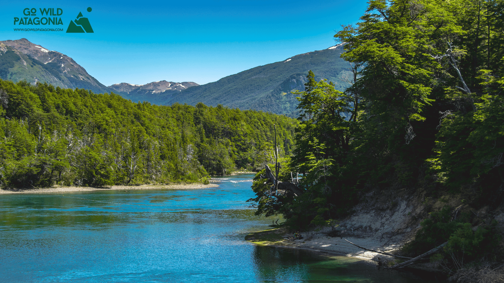
Chubut Province, Argentina — Cathedral of Ancient Trees Overview Los Alerces National Park protects 263,000 hectares of pristine Valdivian rainforest in Argentine Patagonia, home to some of the oldest living trees on Earth. The park's namesake—the alerce tree (Fitzroya cupressoides)—can live over 3,000 years, rivaling California's sequoias and bristlecone pines.
Update on Oct 24, 2025

El Bolsón offers world-class hiking: Refugio Hielo Azul and Refugio Cajón del Azul sit in alpine cirques accessible via multi-day treks, Cerro Piltriquitrón (2,284m) provides panoramic summit views, and Cajón del Azul's turquoise canyon ranks among Patagonia's most photographed day hikes.
Update on Oct 24, 2025

Monte Leon National Park is Argentina's first coastal national park, protecting 40 km of dramatic Atlantic shoreline where the Patagonian steppe meets the sea.
Update on Oct 24, 2025
