
Parque Patagonia (Patagonia National Park)
Patagonia National Park (formerly Patagonia Park, now officially Parque Nacional Patagonia). Free camping throughout, excellent hiking from easy lakeside strolls to strenuous summit climbs, and world-class wildlife viewing make this a must-visit for conservation-minded travelers.

Parque Patagonia (Patagonia National Park)
Aysén Region, Chile — Tompkins' Rewilded Grasslands
Overview
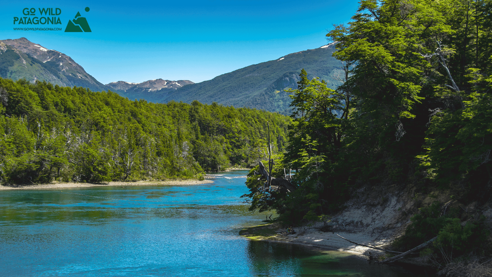
Patagonia National Park (formerly Patagonia Park, now officially Parque Nacional Patagonia) represents Doug and Kris Tompkins' most ambitious rewilding project—289,000 hectares (over 700,000 acres) of restored Patagonian steppe in Valle Chacabuco. Beginning in 2004, the Tompkins purchased degraded cattle ranches, removed 9,000+ head of livestock, dismantled 450 km of fencing, and initiated ecosystem restoration. Today, guanacos roam by the thousands, pumas hunt naturally, Andean condors soar overhead, and grasslands recover from a century of overgrazing. Donated to Chile in 2018 as part of the largest private land donation in history, the park anchors Chile's Route of Parks—17 national parks spanning 1,700 miles from Puerto Montt to Cape Horn. Valle Chacabuco's wide grasslands, backed by Andean peaks and turquoise lakes, offer a different Patagonia than forests or glaciers: open steppe, big sky, rewilding in action. Free camping throughout, excellent hiking from easy lakeside strolls to strenuous summit climbs, and world-class wildlife viewing make this a must-visit for conservation-minded travelers.
Why Visit
Witness rewilding success — See ecosystem restoration in real-time: grasslands recovering, native wildlife populations rebounding, rivers healing. One of world's largest rewilding projects open to public.
Observe abundant wildlife — Guanacos in herds of 50-100+, pumas (elusive but present—tracks, kills, occasional sightings), Andean condors (dozens soaring), huemul deer (endangered—reintroduction underway), foxes, armadillos, over 100 bird species.
Hike diverse trails — From easy Laguna Altas loop (5 km, 2 hrs) to strenuous Cerro Tamango summit (20 km, 8-10 hrs, 1,200m gain). All free, well-maintained, minimal crowds.
Camp for free — Designated campsites throughout valley—pit toilets, no fees, first-come basis. Wild camping ethos with basic infrastructure.
Learn conservation vision — World-class visitor center explains Tompkins' philosophy, rewilding science, Route of Parks concept. Inspiring and educational.
Support visionary project — Visiting demonstrates value of conservation tourism, helping justify park creation to skeptics in Chile.
Getting There
Access via Futaleufú (Most Common):
Distance: 80 km from Futaleufú to Valle Chacabuco park headquarters (1.5 hours drive)
Route: Rough gravel road—2WD manageable but slow. High clearance helpful.
From Futaleufú: Drive west to Villa Santa Lucía junction (Carretera Austral), turn south, then east at signed junction into Valle Chacabuco.
Access via Cochrane (Southern Approach):
Distance: 90 km north from Cochrane (2 hours)
Route: Gravel road from Cochrane heading north, turn west into valley
Note: This route less traveled, more remote
No Public Transport: Must have own vehicle or arrange tour/transfer. Some Futaleufú rafting operators offer day trips or transfers (~$80-100 per person). Hitchhiking possible summer (light traffic).
Important: Bring ALL supplies—food, camping gear, water bottles (refill at streams). No stores, no services except basic visitor center. Nearest town: Cochrane (90 km south) has supermarkets, gas. Cell service nonexistent in park.
Top Experiences
Cerro Tamango Summit Hike — The park's flagship trail. Stats: 20 km round trip, 8-10 hours, 1,200m elevation gain to 2,100m summit. Trailhead: Near park headquarters. Route: Climbs steadily through grasslands, transitions to alpine tundra, rocky summit scramble (non-technical). Views: 360° panorama—entire Valle Chacabuco, Lago Cochrane, Andean peaks, endless steppe. Clear days see Baker River valley. Wildlife: Condors circling, guanacos at all elevations, occasional puma tracks. Difficulty: Strenuous—good fitness required, long day. Best: December-March (snow-free). Start dawn to avoid afternoon wind. Reward: One of Patagonia's finest summit views.
Wildlife Viewing — Exceptional opportunities. Guanacos: Herds throughout valley—hundreds visible. Best viewing: early morning/evening in grasslands near headquarters. Listen for alarm calls (high-pitched whinnies). Pumas: Elusive but present—about 20 individuals in park. See tracks on trails, occasional kills (guanaco carcasses with telltale throat bites). Sightings rare but possible at dawn/dusk. Bring binoculars. Condors: Dozens soar on thermals—massive wingspan (3m), distinctive white neck ruffs. Huemul: Critically endangered Andean deer—reintroduction program underway. Occasional sightings remote valleys. Foxes: Culpeo and chilla foxes hunt grasslands. Birds: Upland geese, Patagonian sierra-finches, black-chested buzzard eagles, many others. Best: Dawn/dusk patrols, patient observation, binoculars/spotting scope.
Laguna Altas Loop — Easy family-friendly hike. Stats: 5 km loop (2 hours), flat/easy. Features: Circuit around small lakes, wetlands with waterfowl, grassland views. Interpretive signs explain rewilding. Wildlife: Upland geese, flamingos (occasional), guanacos. Best for: Acclimatization, families with kids, casual nature walk. Access: Trailhead near headquarters.
Visitor Center Exploration — World-class facility. Architecture: Modern, sustainable design—low-impact, uses natural materials, blends with landscape. Exhibits: Tompkins Conservation history, rewilding science explained with photos/videos, ecological recovery metrics, before/after comparisons showing grassland restoration, Route of Parks vision. Quality: Museum-level interpretation, English/Spanish. Free entry. Time: 1-2 hours. Essential for understanding park's significance. Shop: Small selection of conservation-themed books, apparel (proceeds support park).
Avilés Trail — Moderate day hike. Stats: 12 km round trip (4-5 hours), moderate. Route: Follows Río Avilés through valley, grassland and riparian zones, mountain backdrop. Wildlife: Excellent for guanaco viewing, waterfowl along river. Quieter: Fewer hikers than Laguna Altas. Fishing: Trout in river (catch-and-release, license required).
Lagunas Altas Trek (Extended) — Multi-day backcountry option. Stats: 30+ km, 2-3 days, navigation skills required. Route: Extends from Laguna Altas loop into remote valleys, alpine lakes, high passes. Camping: Backcountry sites (no facilities, carry everything). Register: Mandatory at headquarters before departing. For: Experienced backpackers seeking solitude.
Mountain Biking — Extensive trail network. Trails: Laguna Altas loop (easy), Tamango approach (climbing!), valley roads (gravel, rolling). Rentals: None—bring own bike. Best: November-April. Distance: 20-50 km days depending on route. Wildlife viewing: Excellent from bike—cover more ground than hiking.
Horseback Riding — Occasional outfitters offer rides—ask at headquarters or arrange through Futaleufú operators. Experience: Gaucho-style exploration of grasslands, remote valleys. Season: November-March.
Photography Workshops — Park occasionally hosts photography-focused programs. Subjects: Landscape, wildlife, conservation storytelling. Check: Tompkins Conservation website or at visitor center.
Stargazing — Exceptional dark skies. Light pollution: Zero. Views: Milky Way spectacular, Southern Cross, Magellanic Clouds. Best: New moon periods, winter (clearest but coldest). Camp: Free sites perfect for astro-photography.
Conservation Volunteer Programs — Opportunities to participate in restoration work: fencing removal, trail maintenance, wildlife monitoring. Duration: Usually week-long or more. Info: Contact Tompkins Conservation directly (www.tompkinsconservation.org). For: Those wanting hands-on rewilding experience.
Where to Stay
Inside Park (Camping):
Free designated campsites: Multiple locations throughout Valle Chacabuco. Pit toilets, picnic tables, fire rings. No showers, no fees. First-come, first-served. Sites near headquarters most popular but valley is vast—solitude easy to find. Water: streams throughout (filter recommended).
Backcountry camping: Register at headquarters, follow Leave No Trace principles.
Lodge at Valle Chacabuco:
Only commercial lodging inside park. Comfortable rooms, meals included, activities/guides available (~$200-300 per night with meals). Booking: www.explorevallechacabuco.com. Limited rooms—book ahead.
Nearby Towns:
Cochrane (90 km south): Town of 3,000. Hospedajes ($30-60), Hostel Esquel ($20 dorms), camping, restaurants. Stock up here before park—last services.
Futaleufú (80 km northeast): Adventure town. Hostels, lodges, restaurants (see Futaleufú guide). Alternative staging point.
Best Time to Visit
December-February (Summer Peak): Warmest weather (15-25°C days, 5-10°C nights), longest daylight (5 AM-11 PM). Best hiking conditions—all trails snow-free. Wildlife most active. Guanacos with newborn chulengos (baby guanacos—adorable). Wildflowers throughout grasslands. Wind strong but manageable. Peak visitors (still minimal compared to Torres del Paine—maybe 20-30 people at headquarters on busy day). Camping most comfortable. Best overall for first-timers.
March-April (Autumn): Shoulder season gem. Fewer visitors (nearly solitary), autumn light beautiful for photography, comfortable temps (10-18°C), calmer winds. Guanacos still abundant. Some early snow possible on Tamango summit late April. Services continue. March arguably best month—weather, solitude, mature wildlife viewing. Easter week exception (Chilean holiday—busier).
October-November (Spring): Spring awakening. October still cold (5-12°C), snow on high trails. November improves—wildflowers emerge, guanacos birthing season begins (late Nov). Weather unpredictable—sun alternating cold snaps. Very few visitors. Headquarters open, trails accessible low elevations. Good for pioneers comfortable with variable conditions. Late November approaches summer conditions.
May-September (Winter): Off-season but park remains open. Very cold (0-8°C days, well below freezing nights), short days, heavy snow high elevations. However: Incredible solitude, winter wildlife viewing (guanacos in valleys, pumas more visible hunting, condors soaring snowy peaks), dramatic landscapes, clear skies for stargazing. Only for experienced winter campers with proper gear. Road access can be challenging. Headquarters staffed year-round. For hardcore adventurers.
Sample Itineraries
2-Day Itinerary (Quick Immersion)
Day 1:
Morning: Drive from Futaleufú (1.5 hrs) or Cochrane (2 hrs)
Arrive Valle Chacabuco, park headquarters
Visitor center exploration (1-2 hrs)
Set up camp at designated site
Afternoon: Laguna Altas loop hike (2 hrs)
Wildlife viewing from camp as sun sets
Evening: Campfire, stargazing
Day 2:
Early morning: Wildlife patrol (guanacos, condors)
Breakfast
Morning: Avilés Trail (4-5 hrs) OR half of Tamango ascent
Afternoon: Pack up, drive to next destination
OR: Stay additional night
4-Day Itinerary (Complete Exploration)
Day 1:
Arrive, visitor center deep dive
Easy day: Laguna Altas, camp setup
Wildlife observation evening
Acclimatization
Day 2:
Full-day: Cerro Tamango summit (8-10 hrs)
Early start (6 AM), packed lunch
Summit views, condors
Return exhausted but fulfilled
Evening: Rest, hot meal
Day 3:
Recovery day: Sleep in
Avilés Trail moderate hike (4-5 hrs)
Afternoon: Drive valley roads, different viewpoints
Wildlife photography
Move camp to different site for variety
Day 4:
Morning: Final wildlife viewing
Mountain biking if brought bike
OR: Relax, journal, photography
Afternoon: Depart for Futaleufú or Cochrane
7-Day Itinerary (Extended Wilderness)
Days 1-3: As 4-day itinerary above (arrive, visitor center, Tamango summit, Avilés)
Days 4-6: Multi-day backcountry trek to remote valleys
Register route with rangers
Backpack into Lagunas Altas extended route
Camp remote lakes
Wildlife immersion, photography
Complete solitude
Return Day 6 evening
Day 7: Final morning, pack out, depart
Alternative Days 4-7 (Non-backpackers):
Day 4: Mountain biking valley trails
Day 5: Volunteer day (trail work with rangers if available)
Day 6: Photography day—find best wildlife spots
Day 7: Repeat favorite hike, depart
Where to Go Next
1. Futaleufú — Whitewater Adventure (80 km northeast, 1.5 hours)
Why Go: Pivot from rewilded grasslands to adrenaline capital. Futaleufú River: world-class whitewater (Class IV-V). Multi-day rafting expeditions, kayaking, fly fishing, mountain biking. Creates perfect combination: Patagonia Park's conservation + Futaleufú's adventure. Budget 3-5 days rafting.
2. Cochrane & Southern Carretera Austral (90 km south, 2 hours)
Why Go: Continue south on Carretera Austral. Cochrane: working town (3,000), resupply, rafting Río Baker (Chile's largest river by volume—turquoise). Further south: Caleta Tortel (stilted boardwalk village), Villa O'Higgins (end of road). Budget 5-7 days.
3. Carretera Austral North — Marble Caves & Beyond (Continue north)
Why Go: From Patagonia Park, drive north via Cochrane to Puerto Río Tranquilo (Marble Caves—stunning), Coyhaique (regional capital), Queulat (hanging glacier), eventually Puerto Montt. Complete Carretera Austral journey. Budget 10-14 days north from Patagonia Park.
4. Argentina via Chile Chico — El Chaltén & El Calafate
Why Go: Cross to Argentina at Chile Chico border (130 km from Cochrane), continue on Ruta 40 south to El Chaltén (Fitz Roy trekking) and El Calafate (Perito Moreno Glacier). Creates binational Patagonian journey. Budget 10-14 days Argentine side.
Planning Your Route:
Conservation Tour: Pumalín Park (Tompkins' first project) → Carretera Austral → Futaleufú → Patagonia Park → explore Route of Parks concept
Complete Patagonia: Torres del Paine → cross to Argentina → El Calafate → El Chaltén → Chile via Cochrane/Futaleufú → Patagonia Park → Carretera Austral north
Adventure Combo: Futaleufú rafting (5 days) → Patagonia Park hiking/wildlife (4 days) → Carretera Austral south to Villa O'Higgins
Quick Rewilding Focus: Fly to Coyhaique → drive south → Patagonia Park (3-4 days) → return or continue
Timing Tips:
December-February best weather, wildlife, camping
March excellent for solitude and photography
Budget minimum 2-3 days; 4-5 days ideal for Tamango summit + full exploration
Free camping allows extended stays on tight budgets
Combine with Futaleufú (3-5 days) for complete northern Patagonia experience
Winter (June-Aug) only for experienced, properly equipped
Support conservation by visiting, camping responsibly, donating at visitor center
Bring EVERYTHING—no services, no stores, complete self-sufficiency required
Cell service zero—download offline maps, tell someone your plans
Wildlife photography requires patience—spend multiple days for best opportunities
About Me
Veb
Hey there! I’m Veb and I've traveled solo and in groups for 10+ years in Patagonia - across Chile and Argentina.
I started Go Wild Patagonia with a desire to help other travelers plan their journeys in Patagonia with a focus on adventure, nature and being in the wilderness.
Say Thanks
Support my mission to make Patagonia more accessible for travelers while supporting local tour operators who organize only sustainable travels in Patagonia.
Read More
Chubut Province, Argentina — Cathedral of Ancient Trees Overview Los Alerces National Park protects 263,000 hectares of pristine Valdivian rainforest in Argentine Patagonia, home to some of the oldest living trees on Earth. The park's namesake—the alerce tree (Fitzroya cupressoides)—can live over 3,000 years, rivaling California's sequoias and bristlecone pines.
Update on Oct 24, 2025

El Bolsón offers world-class hiking: Refugio Hielo Azul and Refugio Cajón del Azul sit in alpine cirques accessible via multi-day treks, Cerro Piltriquitrón (2,284m) provides panoramic summit views, and Cajón del Azul's turquoise canyon ranks among Patagonia's most photographed day hikes.
Update on Oct 24, 2025

Monte Leon National Park is Argentina's first coastal national park, protecting 40 km of dramatic Atlantic shoreline where the Patagonian steppe meets the sea.
Update on Oct 24, 2025
