
Parque Nacional Patagonia: The Ultimate Guide for Hikers and Adventurers
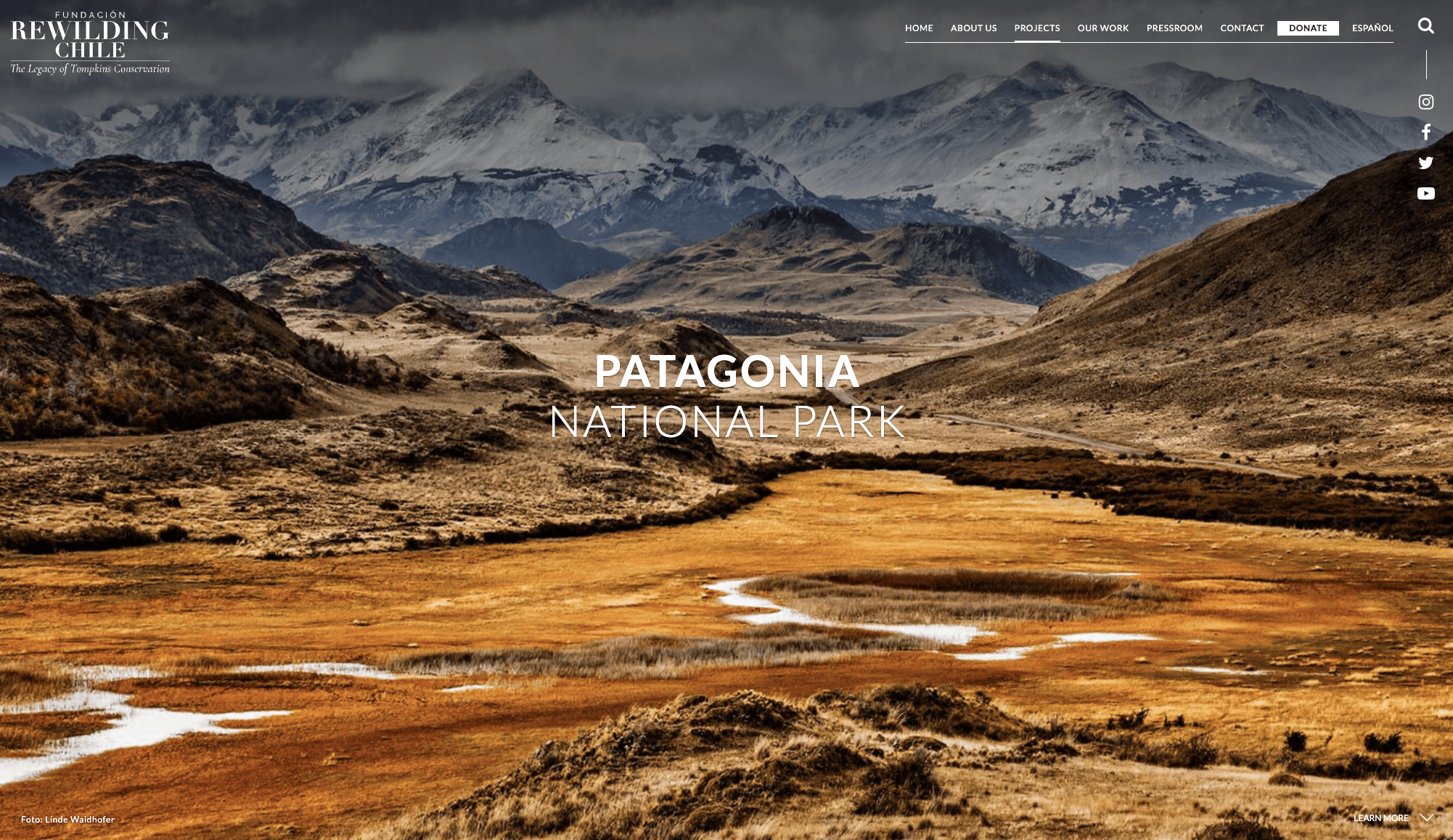
Forget the crowds of Torres del Paine. Parque Nacional Patagonia is where serious adventurers come to experience Patagonia the way it was meant to be experienced: wild, uncrowded, and teeming with wildlife. Parque Nacional Patagonia is divided into three distinct sectors, each with its own character, access points, and adventure opportunities.
Parque Nacional Patagonia: The Ultimate Guide for Hikers & Adventure Seekers
Everything you need to plan the perfect trip to Chile's wildest national park — from day hikes to multi-day traverses, wildlife spotting to backcountry camping
Why Parque Nacional Patagonia Should Be Your Next Adventure
Forget the crowds of Torres del Paine. Parque Nacional Patagonia is where serious adventurers come to experience Patagonia the way it was meant to be experienced: wild, uncrowded, and teeming with wildlife.
Spanning over 304,000 hectares (750,000+ acres) across Chile's remote Aysén Region, this park represents one of the most ambitious rewilding projects in history. Thanks to Doug and Kris Tompkins — founders of The North Face and Patagonia clothing brands — what was once overgrazed ranchland has been transformed into a thriving wilderness where pumas hunt guanacos across vast grasslands, endangered huemul deer browse in ancient lenga forests, and Andean condors circle overhead with their three-meter wingspans.
The park was officially created in 2018 when the Chilean government combined two existing national reserves (Tamango and Jeinimeni) with the donated Chacabuco Valley lands. The result is a park 1.5 times the size of Torres del Paine — but with a fraction of the visitors.
What makes this park exceptional for adventure seekers is its diversity. Within a single multi-day trek, you can traverse glacial river valleys, climb through moss-draped lenga forests, cross high alpine passes with views of the Northern Patagonian Ice Field, and descend into sweeping Patagonian steppe where guanacos roam in herds of 50-100 animals.
Understanding the Park: Three Sectors, Three Experiences
Parque Nacional Patagonia is divided into three distinct sectors, each with its own character, access points, and adventure opportunities. Understanding these sectors is essential for planning your trip.
Sector Tamango (Southern Sector)
Gateway: Cochrane (4 km away) Season: Year-round (only sector open in winter) Entry Fee: 11,400 CLP (~$12 USD) Best For: Huemul deer sightings, kayaking, river activities, accessible day hikes
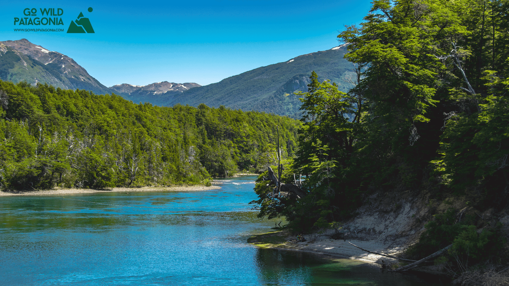
Sector Tamango is the most accessible entry point, located just a 10-minute drive (or 45-minute walk) from Cochrane's Plaza de Armas. Unlike the vast grasslands most people picture when they think of Patagonia, Tamango features native lenga and ñirre forests that blaze brilliant red in autumn, steep topography rising to 1,722 meters on Cerro Tamango, and the impossibly turquoise Río Cochrane — widely considered the most beautiful river in Patagonia.
This sector holds Chile's largest population of endangered huemul deer, making it one of the best places on the continent to spot this shy, elusive animal. The huemul is so culturally significant it appears on Chile's national coat of arms alongside the Andean condor.
Sector Valle Chacabuco (Central Sector)
Gateway: Cochrane (90 km / 2 hours north) Season: October – April only Entry Fee: 8,000 CLP (~$9 USD) Best For: Wildlife viewing (pumas, guanacos, condors), signature day hikes, the park's visitor infrastructure
Valle Chacabuco is the heart of the park and the showcase of the Tompkins Conservation rewilding project. This is where you'll find the iconic Patagonian steppe — vast golden grasslands backed by jagged Andean peaks. Over 450 km of fencing has been removed, 9,000+ head of livestock relocated, and native wildlife has rebounded dramatically.
The transformation is visible in real-time. Guanacos now roam freely in herds of 50-100+ animals, pumas have returned to hunt naturally (with an estimated population of 25-30 adults in the valley alone), and the grasslands are recovering from a century of overgrazing. Camera trap studies have documented pumas using the same trails as hikers — though sightings are never guaranteed, they're increasingly common at dawn and dusk near the West Winds campground.
This sector contains the park headquarters, visitor center, museum, and the majority of the park's infrastructure.
Sector Jeinimeni (Northern Sector)
Gateway: Chile Chico (55 km south) Season: October – April only Entry Fee: 9,000 CLP (~$10 USD) + 10,000 CLP camping Best For: Remote wilderness trekking, otherworldly landscapes, ancient rock art, multi-day traverses
Sector Jeinimeni is the wildest and least visited portion of the park — 161,000 hectares of forest, steppe, and snowy peaks offering true wilderness. The landscapes here feel otherworldly: the milky turquoise waters of Lago Jeinimeni, the surreal Valle Lunar (Moon Valley) with its eroded ridges and reddish rock formations, and the 40-meter-high Piedra Clavada volcanic monolith standing sentinel over the steppe.
This sector also contains significant archaeological heritage, including Cueva de las Manos (Cave of the Hands) with Tehuelche hand stencils dating back over 7,000 years — similar to the famous UNESCO World Heritage Site across the border in Argentina.
Day Hikes: Sector by Sector
Tamango Day Hikes
Sendero Los Carpinteros (#2) — The Must-Do Trail
Distance: 9.5 km out-and-back
Elevation Gain: 323 m (1,060 ft)
Duration: 3–4 hours
Difficulty: Moderate
This undulating trail follows the impossibly turquoise Río Cochrane through exposed rock faces and magical lenga forest. You'll traverse above crystalline waters so clear you can watch trout swimming below. The final mirador offers panoramic views where the river meets Lago Cochrane — one of Patagonia's most photogenic scenes. Pro tip: arrange a boat drop at the campground and hike back one-way for the best experience.
Sendero Las Águilas (#1)
Distance: 6.6 km out-and-back
Elevation Gain: 428 m (1,404 ft)
Duration: 3–4 hours
Difficulty: Hard
A steep but rewarding climb between the Tamango and Húngaro peaks, offering commanding views over Lago Cochrane. This trail connects to Los Huemules trail for those wanting to extend their day.
The Full Tamango Circuit
Distance: ~20 km loop
Duration: Full day (7-9 hours)
Difficulty: Hard
Combine five trails — Las Águilas, Los Huemules, Los Ñires, Los Coigües, and Los Carpinteros — for an epic day that traverses the full diversity of the sector. Expect lenga forests, steppe viewpoints, lakeside walking, and the best chance at huemul sightings.
Valle Chacabuco Day Hikes
Lagunas Altas Loop — The Signature Hike
Distance: 20–23 km loop
Elevation Gain: 975 m (3,200 ft)
Duration: 7–10 hours
Difficulty: Difficult
Named one of "Patagonia's Best Five Treks" by Lonely Planet, this challenging loop climbs steeply from the West Winds campground to stunning alpine lagoons with expansive views of the Chacabuco Valley, Jeinimeni sector, and the Northern Patagonian Ice Field. Guanaco sightings are nearly guaranteed along the way.
Critical tip: Hike counter-clockwise. This takes you up the steepest incline in the first 6 km when you're fresh, then it's mostly flat or downhill for the remaining 14 km. Start early — this is an all-day undertaking with no infrastructure or camping along the trail.
Sendero Avilés Loop
Distance: 16 km loop
Elevation Gain: 457 m (1,500 ft)
Duration: 5–6 hours
Difficulty: Moderate
Follow the beautiful Río Avilés to a spectacular 30-meter-high suspension bridge spanning a dramatic gorge — one of the most impressive man-made features in any Chilean national park. This trail connects to the multi-day Jeinimeni traverse, making it perfect for scouting if you're planning a longer expedition. Trailhead at Camping Casa de Piedra.
Lago Chico / Mirador Douglas Tompkins
Distance: 12 km loop
Elevation Gain: ~400 m (1,300 ft)
Duration: 4–5 hours
Difficulty: Moderate
An excellent half-day option weaving through forest and steppe, descending to beautiful Lago Chico before climbing to the Douglas Tompkins Lookout with sweeping views of Lago Cochrane and the massive Mt. San Lorenzo — one of Patagonia's highest peaks.
Sendero Laguna Cisnes & Stone House Cemetery
Distance: 5-8 km
Duration: 2-3 hours
Difficulty: Easy
A relaxed circuit perfect for families, passing flamingo-filled lagoons and an evocative historic cemetery where the remains of settlers from the former cattle ranch are buried. Excellent bird-watching opportunities.
Jeinimeni Day Hikes
Piedra Clavada / Cueva de las Manos / Valle Lunar Circuit
Distance: 7.5 km circuit (some sources say up to 12 km)
Elevation Gain: 485 m (1,590 ft)
Duration: 3.5–5 hours
Difficulty: Moderate to Hard
Trailhead: Km 25 on Route X-753 (before the main park entrance)
This is the signature Jeinimeni experience, visiting three surreal landscapes in a single circuit. You'll see the 40-meter-high wind-sculpted Piedra Clavada (Nailed Rock) volcanic formation, explore Cueva de las Manos with Tehuelche hand paintings dating back 7,000+ years, and walk through the otherworldly Valle Lunar — whose reddish rock formations, white sands, and steep cliffs look more like northern Chile's Atacama Desert than Patagonia.
Pro tip: Hike clockwise as suggested by park signage — the final descent is steep and better going down than up.
Laguna Esmeralda / Lago Verde Trail
Distance: 10-15 km (depending on turnaround)
Duration: 2–4 hours
Difficulty: Easy to Moderate
An easy trail skirting Lago Jeinimeni to the gorgeous emerald-colored Laguna Esmeralda. Can be extended to Lago Verde and the Valle Hermoso refugio for those wanting a longer day. Beautiful views of the Jeinimeni mountain range throughout.
Mirador Lago Jeinimeni
Distance: ~5 km out-and-back
Duration: 2–3 hours
Difficulty: Moderate
Beginning about 3 km from the El Silencio campsite, this trail ascends a hillside offering panoramic views over the milky turquoise waters of Lago Jeinimeni — one of the most photographed scenes in the northern sector.
Multi-Day Treks: The Ultimate Patagonia Wilderness Experience
The Jeinimeni to Chacabuco Traverse (3–5 Days)
This spectacular multi-day trek connects the Jeinimeni and Valle Chacabuco sectors through the wild Avilés Valley. It's one of Patagonia's emerging classic treks — remote, challenging, and stunningly beautiful. Unlike the crowded W Trek in Torres del Paine, you'll likely have the trail entirely to yourself.
The Stats:
Total Distance: 47+ km (29+ miles)
Duration: 3–5 days (5 recommended for full enjoyment)
Difficulty: Moderate to Hard
Total Ascent: ~2,650 m (8,700 ft)
Total Descent: ~3,290 m (10,800 ft)
Best Season: December – March
Day 1: Lago Jeinimeni to Valle Hermoso
Distance: 15.6 km
Elevation: +425m / -400m
Time: 4.5–6 hours
Start at the ranger station near El Silencio campground. Cross the bridge at the campground trailhead and begin following trail markers. Your first stream crossing comes at 3.8 km. Past Laguna Esmeralda, you'll face the critical Río Jeinimeni crossing — consult rangers about current conditions before attempting. At 7.5 km, climb steeply over Paso Gloria (1,100m) for stunning views of Lago Verde below. Descend to the Valle Hermoso hut, a cute CONAF-built shelter with wood stove, outhouse, and nearby tent sites.
Critical safety note: Cross the largest rivers before noon. Glacial meltwater causes river levels to rise significantly in the afternoon — what's knee-deep at 9am can be waist-deep and dangerous by 3pm.
Day 2: Valle Hermoso to Upper Valle Avilés
Distance: 15.5 km
Elevation: +275m / -370m
Time: 5–6 hours
Exit Valle Hermoso along the riverbed, wading through several streams. At 2.6 km, look carefully for the marker directing you into the lenga forest — it's easy to miss! Cross into Parque Patagonia at approximately 5.5 km (well-marked boundary sign). Continue descending through ancient lenga forest draped with old man's beard moss. Camp above the suspension bridge (km 16-17 area). Important: Wild camping is ONLY permitted above the suspension bridge — below it, you must use designated campgrounds.
Day 3: Valle Avilés to Casa de Piedra
Distance: 16 km
Elevation: +365m / -760m
Time: 4–5 hours
Continue down the Valle Avilés, following the river through increasingly open terrain. The highlight comes when you cross the spectacular suspension bridge — 30 meters long, suspended 30 meters above the gorge, swaying gently in the wind. Below, the Río Avilés churns through a narrow canyon. After the bridge, the landscape transforms dramatically as you descend into the Patagonian steppe — watch for guanacos appearing on the golden grasslands ahead. Arrive at Casa de Piedra campground with hot showers, Wi-Fi, and the satisfaction of completing one of Patagonia's great wilderness traverses.
Optional Extension: The Full Park Traverse (5-6 Days) From Casa de Piedra, continue south via the Lagunas Altas trail and Paso Los Condores into Sector Tamango, eventually reaching Cochrane. This epic 60+ mile route traverses the entire park from north to south.
Essential Gear for Multi-Day Treks
River crossing shoes (old running shoes or water sandals with heel straps)
Trekking poles (essential for river crossings)
4-season tent capable of handling strong winds and rain
Sleeping bag rated to 0°F / -18°C
Full rain gear (jacket and pants)
Water filter (water is plentiful but untreated)
5+ days of food — there is NO food available anywhere in the park
GPS device or phone with offline maps (trails can be faint in places)
Satellite communicator recommended for emergencies
River crossing tip: unbuckle your hipbelt when crossing deep rivers so you can ditch your pack if you fall
Wildlife Watching: Finding Patagonia's Big Five
Parque Nacional Patagonia offers some of the best wildlife viewing in all of Patagonia — rivaling even Torres del Paine for certain species. Here's where and how to find the park's most sought-after animals.
Guanacos
These wild relatives of the llama are abundant throughout the park, particularly in Valle Chacabuco. Herds of 50-100+ animals are common, and you'll often see them grazing right alongside the road on Route X-83. Watch for sentinel guanacos standing alert on ridgelines — they're watching for pumas.
Best viewing: Anywhere in Valle Chacabuco, especially along Route X-83 and during the Lagunas Altas hike.
Pumas
The rewilding project has been remarkably successful for pumas, with an estimated 25-30 adults now living in the Chacabuco Valley alone (population density of about 1.4 pumas per 10,000 acres). Camera traps show pumas regularly using the same trails as hikers.
Best viewing: West Winds campground at dawn and dusk. Listen for the guanacos' alarm cry — a high-pitched sound like a laugh — which signals a puma is nearby. Sentinel guanacos suddenly standing rigid or herds panicking are also good indicators. Sightings are never guaranteed, but increasingly common for those who are patient and know what to look for.
Huemul Deer
This endangered Andean deer (pronounced "way-mool") appears on Chile's national coat of arms. Sector Tamango holds Chile's largest population, making it one of the best places on the continent for sightings.
Best viewing: Around Camping Tamango, particularly in early morning and evening. Rangers report huemuls frequently browsing near the campground. Also look for them in the lenga forests along the Avilés Valley during multi-day treks.
Andean Condors
These magnificent birds with 3-meter wingspans are common throughout the park, often seen circling on thermal updrafts above the valleys.
Best viewing: Mirador Douglas Tompkins, Lagunas Altas trail, and anywhere with dramatic cliff faces. Look up — they're often riding thermals high above.
Darwin's Rhea (Ñandú)
These large flightless birds — South American relatives of the ostrich — were once widespread across the Patagonian steppe but their numbers have declined dramatically. Rewilding Chile operates a captive breeding and reintroduction program in Valle Chacabuco.
Best viewing: Valle Chacabuco steppe, often associating with guanaco herds for mutual protection from predators.
Practical Planning: Everything You Need to Know
Getting There
To Cochrane (for Tamango and Valle Chacabuco):
By bus: Daily services from Coyhaique (Buses Don Carlos, Águilas Patagónicas, Buses Sao Paulo). 8-hour journey, typically departing around 8am.
By car: 315 km south of Coyhaique via the Carretera Austral (5-6 hours)
By air: Charter flights operate from Balmaceda to Cochrane during high season (Oct-Apr), approximately 45 minutes
To Chile Chico (for Jeinimeni):
By ferry: From Puerto Ibáñez across Lago General Carrera (2.5 hours). Book ahead during high season.
By bus: From Coyhaique via Buses Aldea
From Argentina: Easy crossing from Los Antiguos via Paso Río Jeinimeni (4.5 km east of Chile Chico)
Within the Park:
Tamango Sector: 4 km from Cochrane — walkable or short drive
Valle Chacabuco: 90 km from Cochrane. No public transport to the park headquarters. Options: rental car (recommended), hitchhiking (common and generally safe), or expensive private transfers from Cochrane.
Jeinimeni Sector: 55 km from Chile Chico. No public transport. 4x4 recommended. Private transfers available (~20,000 CLP/person with 3+ passengers).
When to Visit
December – February (High Summer): Best weather (15-25°C), longest days (sunrise ~5:30am, sunset ~10pm), all trails open. This is peak season — while still uncrowded compared to Torres del Paine, expect more company on popular trails. Tabanos (biting flies) can be fierce in January.
March – April (Autumn): Arguably the best time to visit. Excellent weather, significantly fewer visitors, and the lenga forests blaze with spectacular fall colors. Rivers are lower, making multi-day trek crossings easier.
October – November (Spring): Variable weather, but wildflowers bloom across the steppe. Guanaco birthing season — watch for adorable chulengos (baby guanacos). Some trails may still have snow at higher elevations.
May – September (Winter): Only Sector Tamango remains open. For experienced winter adventurers only — expect snow, cold temperatures, and shorter days.
Camping
Sector Tamango:
Camping Tamango: 8,000 CLP/person/night. Flushing toilets, showers (supposedly hot), covered picnic shelters. Located 500m from the park entrance on the shores of Río Cochrane. Reserve via WhatsApp: +56 9 9563 1071. Kayak rentals available (singles 15,000 CLP, doubles 25,000 CLP for 3 hours).
Valle Chacabuco:
Camping West Winds: 8,000 CLP/night. Hot showers, toilets, cooking shelters. 2.5 km from park HQ. Lagunas Altas trailhead. Warning: mice are aggressive — hang your food! Puma activity reported.
Camping Casa de Piedra: 8,000 CLP/night. Historic stone building with showers, Wi-Fi (!). Avilés Loop trailhead. Popular end point for the Jeinimeni traverse.
Camping Alto Valley: 8,000 CLP/night. Most remote of the three.
Lodge at Valle Chacabuco: $200-300/night for those wanting luxury with meals included.
Sector Jeinimeni:
Camping El Silencio: 10,000 CLP/night. Basic facilities near ranger station on Lago Jeinimeni. Spacious, shaded drive-in sites.
Valle Hermoso Hut: Backcountry shelter with wood stove — register with rangers before using.
Critical Reminders
NO services in the park. Bring ALL food from Cochrane, Chile Chico, or Coyhaique. The only exception is an expensive restaurant at the Lodge at Valle Chacabuco.
NO cell service. Download offline maps, tell someone your plans, consider a satellite communicator for multi-day treks.
Cash only at most park facilities. ATMs available in Cochrane and Chile Chico.
Weather changes rapidly. Be prepared for four seasons in one day. Waterproof layers are non-negotiable.
Binoculars are essential for wildlife viewing.
Book campsites and ferry crossings in advance during high season (December-February).
Onward Adventures: Where to Go Next
Parque Nacional Patagonia sits at the heart of Chile's Route of Parks — a 2,800 km scenic route connecting 17 national parks from Puerto Montt to Cape Horn. From here, the adventure continues:
Heading South:
Río Baker rafting (Chile's largest-volume river)
Caleta Tortel — the boardwalk village with no roads
Villa O'Higgins — the end of the Carretera Austral
Cross to El Chaltén, Argentina for Fitz Roy and Cerro Torre
Heading North:
Marble Caves (Capillas de Mármol) at Puerto Río Tranquilo
Cerro Castillo National Park — the "next Torres del Paine"
Queulat National Park and its hanging glacier
Pumalín Douglas Tompkins National Park
Into Argentina:
Los Antiguos (via Chile Chico border crossing)
El Chaltén and Los Glaciares National Park
El Calafate and Perito Moreno Glacier
Ruta 40 — Argentina's legendary highway
Parque Nacional Patagonia represents conservation at its most ambitious — proof that wild places can be restored, that wildlife can return, and that the next generation of adventurers can experience Patagonia as it once was. Visit with respect, leave no trace, and carry with you not just photographs, but the memory of a wilderness reborn.
More Patagonia adventure guides at gowildpatagonia.com
About Me
Veb
Hey there! I’m Veb and I've traveled solo and in groups for 10+ years in Patagonia - across Chile and Argentina.
I started Go Wild Patagonia with a desire to help other travelers plan their journeys in Patagonia with a focus on adventure, nature and being in the wilderness.
Say Thanks
Support my mission to make Patagonia more accessible for travelers while supporting local tour operators who organize only sustainable travels in Patagonia.
Read More
Chubut Province, Argentina — Cathedral of Ancient Trees Overview Los Alerces National Park protects 263,000 hectares of pristine Valdivian rainforest in Argentine Patagonia, home to some of the oldest living trees on Earth. The park's namesake—the alerce tree (Fitzroya cupressoides)—can live over 3,000 years, rivaling California's sequoias and bristlecone pines.
Update on Oct 24, 2025

El Bolsón offers world-class hiking: Refugio Hielo Azul and Refugio Cajón del Azul sit in alpine cirques accessible via multi-day treks, Cerro Piltriquitrón (2,284m) provides panoramic summit views, and Cajón del Azul's turquoise canyon ranks among Patagonia's most photographed day hikes.
Update on Oct 24, 2025

Monte Leon National Park is Argentina's first coastal national park, protecting 40 km of dramatic Atlantic shoreline where the Patagonian steppe meets the sea.
Update on Oct 24, 2025
