
Parque Nacional Patagonia: The Beginners Guide
The Beginners Guide for Hikers, Trekkers & Adventure Sports Enthusiasts — Covering All Three Sectors: Tamango, Valle Chacabuco & Jeinimeni
Parque Nacional Patagonia: The Beginners Guide
The Beginners Guide for Hikers, Trekkers & Adventure Sports Enthusiasts — Covering All Three Sectors: Tamango, Valle Chacabuco & Jeinimeni
Introduction to Parque Nacional Patagonia
Parque Nacional Patagonia represents one of the world's most ambitious rewilding projects—a testament to Doug and Kris Tompkins' vision of ecological restoration on a massive scale. Spanning over 304,000 hectares (750,000+ acres) across Chile's Aysén Region, this national park was officially created in 2018 when the Chilean government combined two existing national reserves with the donated Chacabuco Valley lands.
The park is divided into three distinct sectors, each with its own character, access points, and outdoor opportunities:
Sector Tamango (South): Accessed from Cochrane, featuring lenga forests and prime huemul deer habitat
Sector Valle Chacabuco (Central): The park's heart, with vast grasslands, world-class wildlife viewing, and the main visitor facilities
Sector Jeinimeni (North): Accessed from Chile Chico, offering remote glacial lakes, alpine steppe, and ancient rock art
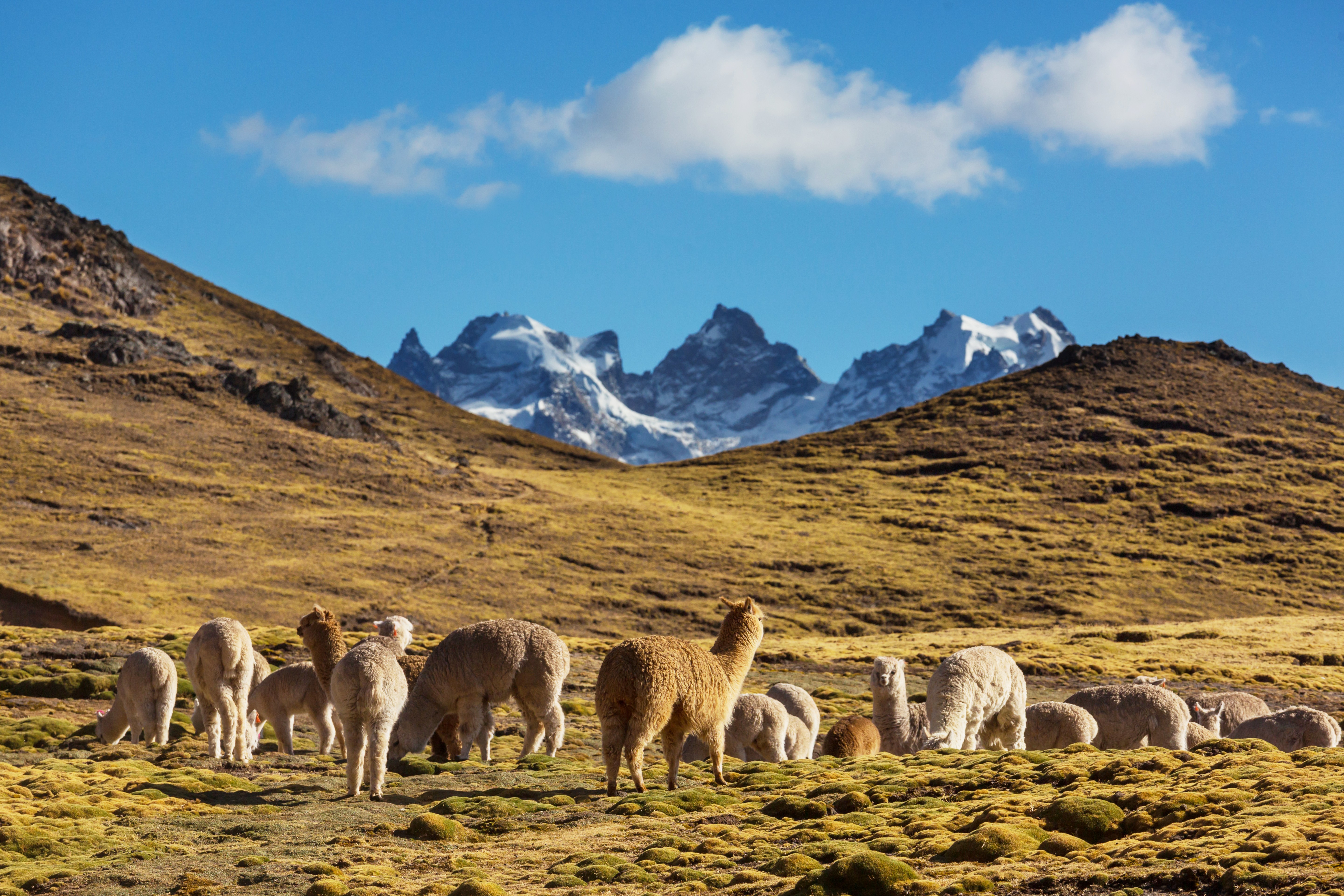
For adventure seekers, this park offers everything from easy lakeside strolls to strenuous summit climbs, multi-day wilderness traverses, mountain biking, kayaking crystal-clear rivers, and some of the best wildlife viewing in Patagonia—including pumas, guanacos by the thousands, endangered huemul deer, and soaring Andean condors.
Quick Reference: Park Sectors at a Glance
Feature | Tamango | Valle Chacabuco | Jeinimeni |
|---|---|---|---|
Gateway Town | Cochrane (4 km) | Cochrane (90 km) | Chile Chico (55 km) |
Season | Year-round | Oct–Apr | Oct–Apr |
Entry Fee | 11,400 CLP | 8,000 CLP | 9,000 CLP |
Best For | Huemul deer, kayaking | Pumas, guanacos | Remote trekking |
Sector Tamango
The Southern Gateway — Best for Huemul Deer & River Adventures
Overview
Sector Tamango (formerly Reserva Nacional Lago Cochrane o Tamango) is the most accessible sector, located just 4 km from Cochrane. Unlike the vast grasslands of Valle Chacabuco, Tamango features native lenga and ñirre forests that blaze red in autumn, steep topography rising to over 1,700m on Cerro Tamango, and the stunning turquoise Río Cochrane—considered by many the most beautiful river in Patagonia. This sector is renowned as one of the best places in Chile to spot the endangered huemul deer.
Getting There & Practical Info
Distance from Cochrane: 4.3 km from Plaza de Armas (10 min drive, walkable)
Hours: Daily 8:30 AM – 5:30 PM (last entry 5:00 PM)
Entry Fee: 11,400 CLP (~$12 USD)
Season: Open year-round (only sector open in winter)
Featured Trail: Sendero Los Carpinteros (#2)
Distance: 9.5 km out-and-back | Elevation Gain: 323 m | Duration: 3–4 hours | Difficulty: Moderate
This undulating trail follows the impossibly turquoise Río Cochrane through exposed rock faces and magical lenga forest. The final mirador offers panoramic views of the river meeting Lago Cochrane. Boat transfers available to hike one-way.
Other Trails
Sendero Las Águilas (#1): 6.6 km, 428m gain, hard—steep climb between peaks
Extended Loop (~13 km): Las Águilas → Los Huemules → Los Ñires → Los Carpinteros
Epic Loop (~20 km): Combine five trails for an all-day adventure
Adventure Activities
Kayaking: Rentals at Camping Tamango—singles 15,000 CLP, doubles 25,000 CLP (3 hrs)
Boat Tours: Scenic tours or one-way drops via campground or Paseos Nauticos Cochrane
Scuba Diving: Lago Cochrane's exceptional clarity makes for unique diving—arrange in town
Camping & Wildlife
Camping Tamango: 8,000 CLP/person/night. Toilets, showers, potable water. 500m from entrance on Río Cochrane shores. Reserve via WhatsApp: +56 9 9563 1071
Huemul Deer: Best place in Chile for sightings—frequently spotted around campground
Also: Magellanic woodpeckers, foxes, trout visible in crystal waters
Sector Valle Chacabuco
The Heart of the Park — Rewilding in Action
Overview
Sector Valle Chacabuco is the flagship of the Tompkins Conservation rewilding project. This is where you'll find iconic Patagonian steppe—vast grasslands backed by Andean peaks, the world-class Museum and Visitor Center, and the transformation visible in real-time: over 450 km of fencing removed, 9,000+ livestock relocated, and native wildlife rebounding dramatically. Guanacos now roam in herds of 50-100+, pumas hunt naturally, and grasslands are recovering from a century of overgrazing.
Getting There & Practical Info
From Cochrane: 90 km north (2 hrs). Turn east onto Route X-83 at signed junction
From Coyhaique: 315 km south via Carretera Austral (5-6 hrs)
Season: October – April only
Entry Fee: 8,000 CLP/person/day
Important: NO public transport—own vehicle, tour, or hitchhike. NO services—bring all food!
Major Trails
Lagunas Altas Loop — The Signature Hike
Distance: 20–23 km loop | Elevation Gain: 975 m | Duration: 7–10 hours | Difficulty: Difficult
Named one of "Patagonia's Best Five Treks," this challenging loop climbs steeply to stunning alpine lagoons with expansive views of the valley, Northern Patagonian Ice Field, and Mt. Tamanguito. Guanaco sightings nearly guaranteed.
Sendero Avilés Loop
Distance: 16 km loop | Elevation: 457 m | Duration: 5–6 hours | Difficulty: Moderate
Follows the beautiful Río Avilés to a spectacular 30m-high suspension bridge. Connects to the multi-day Jeinimeni traverse. Trailhead at Camping Casa de Piedra.
Lago Chico / Mirador Douglas Tompkins
Distance: 12 km loop | Duration: 4–5 hours | Difficulty: Moderate
Excellent half-day option with sweeping views of Lago Cochrane and Mt. San Lorenzo from the Douglas Tompkins Lookout.
Adventure Activities
Mountain Biking: Many trails excellent for biking—no rentals, bring your own
Bikepacking: Epic loop connecting to Argentina via Paso Roballos
Horseback Riding: Gaucho-style exploration available through local outfitters (Nov–Mar)
Fly Fishing: Rivers offer trout fishing (catch-and-release, license required)
Camping
Camping Los West Winds: 8,000 CLP/night. Hot showers, toilets, shelters. 2.5 km from HQ. Warning: mice and pumas!
Camping Casa de Piedra: 8,000 CLP/night. Historic stone building with showers, Wi-Fi. Avilés trailhead
Lodge at Valle Chacabuco: $200-300/night luxury option with meals
Wildlife Highlights
Guanacos: Herds of 50-100+ throughout valley
Pumas: ~20 in park. Best at West Winds at dawn/dusk
Andean Condors: Dozens daily—3m wingspan
Also: Darwin's rhea (reintroduced), Chilean flamingos, armadillos, vizcachas
Sector Jeinimeni
The Remote Northern Sector — Glacial Lakes & Ancient Rock Art
Overview
Sector Jeinimeni (formerly Reserva Nacional Lago Jeinimeni) is the wildest and least visited sector—161,000 hectares of forest, steppe, and snowy peaks offering true wilderness. This sector features glacial lakes, surreal rock formations including the 40m Piedra Clavada, ancient Tehuelche cave paintings, and the starting point for multi-day traverses. The landscapes feel otherworldly—the Valle Lunar, milky turquoise Lago Jeinimeni, and alpine steppe create an unforgettable experience.
Getting There & Practical Info
From Chile Chico: 55 km south on Route X-753 (1.5 hrs). 4x4 recommended
To Chile Chico: Ferry from Puerto Ibáñez (2 hrs) or cross from Los Antiguos, Argentina
Season: October – April only
Entry Fee: 9,000 CLP/day + 10,000 CLP camping
Transport: No public transit. Private transfer ~20,000 CLP/person (3+ passengers)
Featured Trail: Piedra Clavada / Cueva de las Manos / Valle Lunar
Distance: 7.5 km circuit | Duration: 4 hours | Difficulty: Moderate
Trailhead: Km 25 on Route X-753 (before main entrance)
A fantastic circuit visiting surreal landscapes: the 40m-high wind-sculpted Piedra Clavada volcanic formation, Cueva de las Manos with Tehuelche hand paintings, and the otherworldly Valle Lunar with its eroded ridges.
Laguna Esmeralda Trail
Distance: 10 km | Duration: 2–3 hours | Difficulty: Easy
Easy trail skirting Lago Jeinimeni to gorgeous Laguna Esmeralda. Can extend to Lago Verde and Valle Hermoso refugio.
Camping & Archaeological Sites
Camping El Silencio: 10,000 CLP/night. Basic facilities near ranger station on Lago Jeinimeni
Valle Hermoso Hut: Backcountry shelter with wood stove—register with rangers
The sector contains caves with rock art from the Aonikenk (Tehuelche) people, including hand stencils similar to the famous UNESCO site in Argentina. Over 300 archaeological sites identified in the broader region.
The Jeinimeni to Chacabuco Traverse
A 3–5 Day Multi-Day Trek Through Three Ecosystems
Trek Overview
This spectacular multi-day trek connects the Jeinimeni and Valle Chacabuco sectors through the wild Avilés Valley, traversing glacial river valleys, lenga forests, high passes, and descending into vast Patagonian steppe. It's one of Patagonia's emerging classic treks—remote, challenging, and stunningly beautiful.
Total Distance: 47+ km (29+ mi)
Duration: 3–5 days (5 recommended)
Difficulty: Moderate to Hard
Key Challenges: Multiple cold river crossings, variable weather, navigation
Best Season: December – March
Day 1: Lago Jeinimeni to Valle Hermoso
Distance: 15.6 km | Elevation: +425m / -400m | Time: 4.5–6 hours
Start at ranger station, cross bridge at campground trailhead
First stream crossing at 3.8 km
CRITICAL: Major Río Jeinimeni crossing past Laguna Esmeralda—consult ranger!
At 7.5 km, climb steeply over pass to stunning Lago Verde views
Camp at Valle Hermoso hut (wood stove, outhouse, tent sites)
Tip: Cross largest river before noon—water levels rise in afternoon.
Day 2: Valle Hermoso to Upper Valle Avilés
Distance: 15.5 km | Elevation: +275m / -370m | Time: 5–6 hours
Exit Valle Hermoso along riverbed with stream wading
At 2.6 km, look for marker into lenga forest (easy to miss!)
Cross into Parque Patagonia at ~5.5 km (well-marked boundary)
Camp above suspension bridge (km 16-17). Wild camping ONLY allowed above bridge!
Day 3: Valle Avilés to Casa de Piedra
Distance: 16 km | Elevation: +365m / -760m | Time: 4–5 hours
Continue down Valle Avilés
Cross spectacular suspension bridge—100 ft long, 100 ft above gorge!
Descend into Valle Chacabuco—stunning steppe views open up
Arrive Casa de Piedra campground (hot showers, Wi-Fi!)
Option: Continue to Tamango via Lagunas Altas/Paso Los Condores for 5-6 day epic traverse
Essential Gear
River crossing shoes, trekking poles, 4-season tent, 0°F sleeping bag
Full rain gear, water filter, 5+ days food (NO food in park)
GPS with offline maps, satellite communicator recommended
Practical Planning Information
Best Time to Visit
December–February: Best weather (15-25°C), longest days, all trails open. Peak season
March–April: Arguably best—excellent weather, fewer visitors, stunning fall colors
October–November: Variable weather, wildflowers, guanaco birthing season
May–September: Only Tamango open. For experienced winter adventurers only
What to Bring
2L+ water (filter for refills), sun protection, rain gear, warm layers
Binoculars (essential!), trekking poles, headlamp, offline maps
CRITICAL: NO services in park—bring ALL food from Cochrane or Chile Chico. NO cell service—download maps, tell someone your plans.
Where to Go Next
South: Río Baker rafting, Caleta Tortel, Villa O'Higgins
North: Marble Caves, Cerro Castillo NP, Queulat
Argentina: El Chaltén (Fitz Roy), El Calafate (Perito Moreno)
Route of Parks: 17 national parks from Puerto Montt to Cape Horn
For more Patagonia guides, visit gowildpatagonia.com
About Me
Veb
Hey there! I’m Veb and I've traveled solo and in groups for 10+ years in Patagonia - across Chile and Argentina.
I started Go Wild Patagonia with a desire to help other travelers plan their journeys in Patagonia with a focus on adventure, nature and being in the wilderness.
Say Thanks
Support my mission to make Patagonia more accessible for travelers while supporting local tour operators who organize only sustainable travels in Patagonia.
Read More
Chubut Province, Argentina — Cathedral of Ancient Trees Overview Los Alerces National Park protects 263,000 hectares of pristine Valdivian rainforest in Argentine Patagonia, home to some of the oldest living trees on Earth. The park's namesake—the alerce tree (Fitzroya cupressoides)—can live over 3,000 years, rivaling California's sequoias and bristlecone pines.
Update on Oct 24, 2025

El Bolsón offers world-class hiking: Refugio Hielo Azul and Refugio Cajón del Azul sit in alpine cirques accessible via multi-day treks, Cerro Piltriquitrón (2,284m) provides panoramic summit views, and Cajón del Azul's turquoise canyon ranks among Patagonia's most photographed day hikes.
Update on Oct 24, 2025

Monte Leon National Park is Argentina's first coastal national park, protecting 40 km of dramatic Atlantic shoreline where the Patagonian steppe meets the sea.
Update on Oct 24, 2025
