
Chile Patagonia Adventure Guide: Trekking, Climbing & Wilderness
Chilean Patagonia doesn't just offer adventure; it demands you shed your everyday skin and remember what it means to feel genuinely small, genuinely alive, genuinely present. Stretching from the Aysén Region in the north to the Magallanes in the south, Chilean Patagonia encompasses some of the most dramatic wilderness on Earth.
Chile Patagonia Adventure Guide: Trekking, Climbing & Wilderness
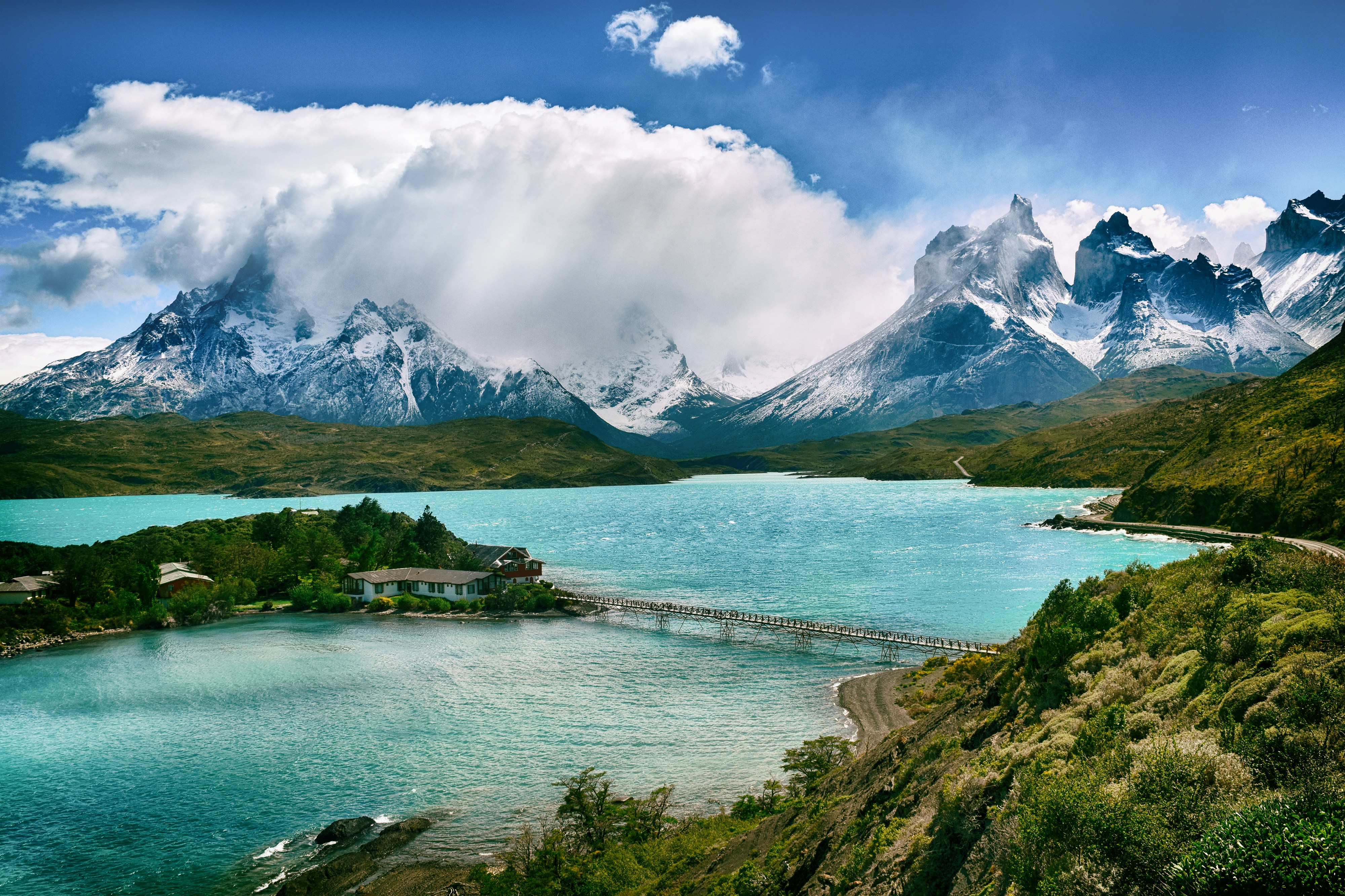
There's a moment that happens to every traveler in Chilean Patagonia—when you round a bend on a windswept trail, and suddenly the granite spires of Torres del Paine pierce the sky like ancient sentinels, or when you stand before a turquoise lake so vivid it seems photoshopped by nature itself. I've experienced that breathless pause dozens of times, and it never gets old. Chilean Patagonia doesn't just offer adventure; it demands you shed your everyday skin and remember what it means to feel genuinely small, genuinely alive, genuinely present.
Stretching from the Aysén Region in the north to the Magallanes in the south, Chilean Patagonia encompasses some of the most dramatic wilderness on Earth. Unlike its Argentine counterpart across the Andes, Chile's side offers superior infrastructure for adventurers, better accessibility to remote regions, and an astonishing diversity of landscapes compressed into a relatively compact area. Within a two-week trip, you can trek beneath hanging glaciers, climb technical granite towers, paddle alongside calving icebergs, and track pumas through windswept grasslands.
This guide cuts through the noise to give you what you actually need: honest assessments of Chile's premier trekking routes, technical climbing opportunities that range from accessible scrambles to serious alpine objectives, and wilderness experiences that extend far beyond the (admittedly spectacular) Greatest Hits of Torres del Paine. Whether you're planning your first multi-day trek or your fifth Patagonian climbing expedition, you'll find actionable information rooted in real experience.
The window for Chilean Patagonia adventures runs primarily from November through March, with December through February offering the most stable weather and longest days. Shoulder seasons bring fewer crowds and dramatic lighting, but expect more challenging conditions. As for fitness, day hikes require basic conditioning, multi-day treks demand solid endurance, and technical objectives need legitimate alpine experience—there's something here for every level, but Patagonia rewards preparation and punishes hubris.
Understanding Chilean Patagonia's Geography & Climate
Regional Breakdown
Chilean Patagonia divides naturally into two distinct zones. Northern Patagonia, encompassing the Aysén Region, centers around the legendary Carretera Austral (Route 7) and includes jewels like Lago General Carrera with its swirling Marble Caves, the temperate rainforests of Queulat National Park with its improbable hanging glacier, and the dramatically undervisited Cerro Castillo Reserve. This region feels wilder, less trampled, more pioneering—you'll spend more time figuring out logistics and less time dodging Instagram photographers.
Southern Patagonia, primarily the Magallanes Region, revolves around Torres del Paine National Park and uses Puerto Natales and Punta Arenas as gateway cities. This is where Chilean Patagonia reveals its showstopper landscapes: the iconic granite towers, the Southern Patagonian Ice Field's massive glaciers, and the windswept steppes where guanacos roam in herds hundreds strong. Infrastructure here accommodates international tourism, which means both easier logistics and more company on popular trails.
The key difference from Argentine Patagonia isn't just geography—it's accessibility. Chile's side benefits from better road networks, more frequent transportation, and a longer-established tourism infrastructure. The weather can be equally brutal on both sides of the Andes, but Chile's coastal proximity creates different microclimate patterns worth understanding.
Climate & Weather Patterns
Let's address the notorious Patagonian wind immediately: it's real, it's relentless, and it will test every stake on your tent. The prevailing westerlies scream across the Southern Patagonian Ice Field, accelerate through mountain passes, and blast the eastern slopes with sustained winds that regularly hit 60-80 km/h, with gusts far higher. I've been pinned in my tent for twelve hours straight, watched my trekking poles bend nearly horizontal, and learned to cook breakfast lying flat to avoid losing my stove to a gust. This isn't an exaggeration for dramatic effect—this is Tuesday in Patagonia.
Spring (November) brings wildflowers and melting snow, but weather remains highly unstable with significant temperature swings. Summer (December-February) offers the most reliable conditions, longest daylight hours (sunset around 10 PM in late December), and warmest temperatures—though "warm" means 10-15°C most days, colder at altitude. Autumn (March-April) delivers spectacular light for photography, fewer tourists, and increasing weather volatility as winter approaches.
Microclimate variations matter tremendously. The western slopes facing the Pacific receive massive precipitation and support temperate rainforests. Eastern areas in the rain shadow run drier and windier. Torres del Paine's weather can shift violently within hours—I've experienced sunshine, rain, snow, and hail in a single afternoon. The reliable pattern is unpredictability.
Pack for four seasons in your backpack: merino wool base layers, insulating mid-layers, waterproof/breathable shell, warm hat, gloves, and buff. Bring sunglasses and sunscreen for high-altitude UV exposure. A sturdy four-season tent isn't overkill if you're camping; three-season tents work but choose models designed for high winds. The Patagonian weather won't meet you halfway—you need to be ready for its worst.
Access & Logistics
Most Chilean Patagonia adventures begin in one of three gateway cities. Puerto Natales serves Torres del Paine, sitting 112 km from the park entrance with regular bus connections, rental car options, and the highest concentration of outdoor gear shops and tour operators. Punta Arenas, about 250 km south of Puerto Natales, offers the region's main airport with flights to Santiago and occasional international connections. Coyhaique serves as the hub for northern Patagonia adventures, providing access to the Carretera Austral, Cerro Castillo, and Lago General Carrera.
Transportation along the Carretera Austral relies heavily on buses that run a few times weekly between major towns—plan carefully and build flexibility into your schedule. Rental cars provide vastly more freedom but come with gravel-road challenges, limited fuel stations, and higher costs. Ferry crossings are required at several points; reserve these in advance during peak season.
Border crossings with Argentina happen frequently for adventurers combining both countries. The main crossings near Torres del Paine (Cerro Castillo/Cancha Carrera) and further north stay open year-round, though hours vary. Carry your passport always, declare all food items, and expect delays. Some multi-day treks like the Dientes de Navarino circuit cross no borders but feel more remote than international expeditions elsewhere.
Torres del Paine National Park: The Crown Jewel
Park Overview
Torres del Paine earned its UNESCO Biosphere Reserve designation through sheer geological drama and ecological significance. The park's namesake granite towers—three vertical spires of pale rock rising over 2,500 meters—formed roughly 12 million years ago as magma intrusions that cooled slowly beneath sedimentary rock, which later eroded away to reveal these massive monoliths. The Paine Massif also includes the Cuernos (horns) with their distinctive dark sedimentary caps over lighter granite, the sprawling Southern Patagonian Ice Field feeding massive glaciers like Grey and Dickson, and an intricate system of turquoise lakes colored by glacial flour.
Wildlife viewing here rivals anywhere on the continent. Guanacos—wild relatives of llamas—graze in herds across the steppe, their tawny coats blending with the blonde grasses until hundreds suddenly materialize around you. Torres del Paine supports one of Chile's healthiest puma populations; dedicated watchers see these magnificent cats regularly, especially around Laguna Amarga and the eastern valleys. Andean condors circle updrafts above ridgelines, their three-meter wingspans unmistakable. Grey foxes trot through campsites at dusk looking for scraps (don't feed them). And if you're exceptionally fortunate, you might spot the endangered huemul deer, a stocky, barrel-chested cervid that once ranged across Patagonia but now survives in scattered populations.
The park receives roughly 300,000 visitors annually, with the vast majority completing the W Trek. This popularity brings both advantages (excellent infrastructure, rescue capabilities, trail maintenance) and drawbacks (permit headaches, crowded viewpoints, environmental pressure). Go expecting company on the classics, then seek solitude on lesser-trodden alternatives.
The W Trek (4-5 Days)
The W Trek traces a west-to-east route below the Paine Massif's southern face, creating a "W" shape when mapped. Most hikers tackle it in four to five days, staying in refugios (mountain huts) or designated campsites. The route divides into three major sections or "arms" of the W, each offering distinct landscapes.
The western arm climbs Valle Francés (French Valley), a spectacular glacial valley flanked by the Cuernos on one side and the sheer walls leading to Paine Grande on the other. The approach parallels a milky river before ascending steeply through lenga forest into the alpine zone. The mirador (viewpoint) at the valley's head provides wraparound views of hanging glaciers, rock walls, and the occasional ice-calving thunder. Allow 6-8 hours for the round trip from Refugio Paine Grande or Campamento Italiano.
The central base serves as the hub where most trekkers begin or end: Refugio Paine Grande sits on the shore of Lago Pehoé with stunning views across to the Cuernos. From here, trails lead to Glacier Grey in the west and connect eastward toward the circuit's final arm.
The eastern arm—the money shot—climbs to Mirador Base Torres, the viewpoint beneath the three towers themselves. This section demands the most effort: roughly 900 meters of elevation gain over about 8 kilometers one-way from Refugio Torre Central or Campamento Torres. The final hour scrambles up a boulder-strewn moraine that tests your knees and patience, but cresting that final rise to see the towers reflected in a small glacial tarn makes everything worthwhile. Time your arrival for sunrise if possible; the towers glow orange-pink as first light hits them, though this requires a brutal 3:30 AM start from Torre Central.
Refugios provide beds, hot meals, and showers (cold to lukewarm). Camping costs significantly less but requires carrying full gear and cooking equipment. Book both options months in advance for peak season (December-February)—literally as soon as reservations open. Three main companies operate refugios: Fantástico Sur on the eastern side, Vértice Patagonia in the central section, and Grey Glacier in the west. You can mix camping and refugio nights, but coordinate carefully to ensure campsite and trail access.
Daily distances range from 11-18 kilometers depending on your exact itinerary and side trips. Most trekkers with reasonable fitness find the W challenging but achievable. The terrain varies from flat lake shores to steep valley ascents. Weather delays happen; build an extra day into your schedule if possible.
The O Circuit (7-9 Days)
The full circuit adds the "backside" of the Paine Massif to the W route, creating an extended loop that delivers far more solitude and wilderness immersion. From Refugio Grey at the W's western end, the circuit continues north along Glacier Grey, crosses the legendary John Gardner Pass, then loops back around the eastern side through remote valleys before rejoining the W route at its eastern terminus.
John Gardner Pass represents the circuit's crux—a 1,200-meter climb followed by an equally steep descent, often in challenging weather conditions. The pass tops out at about 1,200 meters, exposing you to full Antarctic winds howling off the ice field. I've crossed it in whiteout conditions where navigation relied entirely on GPS and the occasional cairn materialized from the snow. I've also crossed it on bluebird days when the panorama of the Southern Patagonian Ice Field stretched endlessly westward, a frozen ocean of white beneath cerulean sky. Weather dictates everything up here.
The backside offers genuine solitude compared to the W. You'll share the trail with dozens instead of hundreds. Campsites like Paso and Los Perros sit in wild, exposed locations that feel genuinely remote. Wildlife sightings increase. The landscape shifts from forests to moonscapes of glacial moraine to vast steppe. This is the Torres del Paine that reveals itself to those willing to carry heavier packs and commit more time.
Gear requirements increase substantially: you need a proper four-season tent that can handle extreme winds, a sleep system rated to at least -5°C, and full backpacking self-sufficiency since refugios don't exist on the backside. Bring microspikes for potential snow and ice on John Gardner Pass. Navigation skills matter more, though the trail remains generally well-cairned.
Book the O Circuit even earlier than the W—a year in advance isn't excessive for peak season. CONAF (Chile's National Forest Corporation) limits daily entries to minimize environmental impact. Most hikers complete the circuit in 7-9 days depending on weather delays and personal pace.
Day Hikes & Shorter Options
Not everyone has a week for the full circuit, and that's fine—Torres del Paine rewards day visitors too. The Mirador Base Torres works as a long day hike from the park's eastern access point. Start from Hotel Las Torres or the welcome center, follow the valley north, and grind up to the viewpoint. Budget 8-10 hours round trip. It's brutal as a day hike (1,800 meters of elevation gain/loss total), but doable for fit hikers.
Lago Grey offers easier options: kayak trips paddle among icebergs calved from Glacier Grey, getting eye-level with centuries-old ice in electric blue hues. The glacier's face stretches over a kilometer wide; chunks calve regularly with thunder and splash. Multiple operators run half-day and full-day trips from the Refugio Grey area.
Salto Grande, a powerful waterfall connecting Lago Nordenskjöld and Lago Pehoé, requires only a short walk from the road and provides excellent wildlife spotting opportunities. I've watched condors soar at eye level from the viewpoint and photographed guanacos grazing against backdrops of turquoise water and granite peaks.
The Cuernos viewpoint, accessible from the administration building, offers a shorter trek with spectacular Paine Massif views. Several other trails throughout the park provide excellent half-day or full-day options for those staying in Puerto Natales or park accommodations.
Practical Information
Park entrance fees run approximately $40 USD for foreigners in high season (December-February), $21 in shoulder season, payable by card at entrance gates. Fees fund park maintenance and conservation efforts. Entry permits, separate from camping/refugio reservations, can be obtained online through the official Chilean national parks website or at park entrances if you're visiting as a day tripper.
The reservation system for camping and refugios can frustrate even experienced travelers. You must book specific campsites for specific nights through the companies that manage different sections of the park. This requires planning your exact itinerary months ahead and hoping weather cooperates with your reservations. Flexibility becomes nearly impossible during peak season.
Food options inside the park cost substantially more than outside. Refugios serve meals (breakfast and dinner packages available with lodging), but prices reflect the remote location. Most campers carry dehydrated meals, energy bars, and other lightweight foods from Puerto Natales. Water from streams requires filtration; I've used a Sawyer Squeeze for years without issues.
Porter services exist for those wanting to trek without full packs. Horses carry gear between designated campsites, though this adds significant cost. Guide services range from basic trail guidance to fully supported expeditions with tents set up, meals prepared, and everything managed. For first-timers or those less comfortable with wilderness navigation, guides provide valuable peace of mind, though the main trails stay well-marked enough for independent travel.
Technical Climbing Opportunities
Torres del Paine Climbing
The Torres themselves tempt climbers from around the world, though attempting them requires serious commitment. The Central Tower (Torre Central) sees the most ascents via the South African Route (5.10+ A0, 800m), first climbed in 1963. The North Tower (Torre Norte) presents more technical challenges, while the South Tower (Torre Sur) offers the most difficult climbing with routes up to 5.12.
Permit requirements for climbing within Torres del Paine have tightened significantly in recent years. You must register with CONAF, provide detailed itineraries, show proof of climbing experience and insurance, and pay additional fees beyond standard park entrance. The park takes safety seriously after several climbing accidents; rescue resources exist but remain limited by weather and helicopter availability.
Technical grades on the Torres span a wide range. The easiest routes require solid 5.10 leading skills, crack climbing proficiency, and multi-pitch experience. Weather creates the primary challenge—climbers often spend days waiting for good conditions, then push hard during brief windows. Rock quality varies; some sections offer stellar granite, while others crumble unexpectedly. Fixed protection exists on popular routes but shouldn't be trusted implicitly.
December through February provides the best climbing season, with the longest days and most stable weather. Even so, expect storms to blow through regularly. I've met climbers who spent three weeks attempting the Central Tower and never got past the third pitch. I've also met teams that climbed it in perfect conditions and descended in a single long day. Patagonian climbing demands patience, flexibility, and thick skin for failure.
Paine Grande & Cuernos
Beyond the towers, the Paine Massif offers numerous other objectives. Paine Grande itself tops out at 2,884 meters as the park's highest peak, though the approach and climb require serious mountaineering skills including glacier travel and ice climbing. The Cuernos present multi-pitch rock routes on their granite lower sections, with mixed climbing possibilities on the sedimentary upper bands.
These objectives see far fewer attempts than the towers, meaning less information exists about specific routes and conditions. Hiring a local guide with current knowledge makes sense for most teams. The approach distances from park infrastructure can be substantial—budget extra days for approaches and weather delays.
Ice and mixed climbing opportunities proliferate throughout winter (June-August), though this season brings extreme weather that limits climbing days severely. Summer ice routes exist on the glaciers and in shaded gullies, particularly on south-facing aspects that stay frozen.
Cerro Castillo Circuit Area
Four hours north of Puerto Natales, the Cerro Castillo massif offers spectacular climbing in a far less-visited setting. The area features quality granite similar to Patagonia's classics but with almost no climbers. Route development remains sparse and adventurous—expect to place all your own protection and navigate based on photographs and vague descriptions rather than detailed topos.
The primary draw for most visitors is the incredible trekking circuit (detailed later), but climbers looking for exploratory objectives in a genuine wilderness setting should investigate this area. Rock quality varies; test holds carefully before committing. Approaches can be long and brushy. Cell service doesn't exist. You're truly on your own, which appeals to some and terrifies others.
Fitz Roy Range Access from Chile
While Fitz Roy and Cerro Torre technically sit in Argentina, Chilean approach options exist. The Chilean side receives far less traffic than the approach via El Chaltén. Some climbing teams use Chilean estancias as base camps, then cross into Argentina to access the peaks. Logistics become complex with border crossings, different permit systems, and longer approach distances, but solitude increases proportionally.
This option suits teams with significant time, logistical patience, and a preference for wilderness over convenience. Most climbers still approach from El Chaltén for good reasons—it's faster, easier, and supported by established infrastructure. But if you're already in Chile and want to avoid backtracking to Argentina, Chilean approaches exist.
Essential Climbing Considerations
Guide services versus independent climbing depends entirely on your experience level and risk tolerance. If you lack extensive multi-pitch experience, Patagonian weather knowledge, or rescue self-sufficiency, hire a guide. Reputable operators include Bigfoot Patagonia, Chile Nativo, and several others based in Puerto Natales. Expect to pay $200-400+ per day for professional guiding depending on group size and objective.
Rescue protocols in Chilean Patagonia involve CONAF, local mountain rescue teams, and potentially helicopter evacuation if weather permits. Response times vary dramatically based on weather, location, and available resources. Comprehensive climbing insurance that covers rescue costs is non-negotiable. Medical evacuation from remote areas can cost tens of thousands of dollars.
Equipment rental in Puerto Natales covers basics like ice axes, crampons, and harnesses, but technical climbing gear (cams, nuts, ropes) requires bringing your own or renting in larger cities like Punta Arenas or Santiago. Gear quality at rental shops varies; inspect everything carefully before heading into the mountains.
Weather forecasting for climbing becomes part art, part science, part gambling. The Mountain Forecast website (mountain-forecast.com) provides specific predictions for major peaks. Local knowledge from guides and other climbers helps interpret forecasts. That said, I've seen forecasts bust completely—predicted four days of clear weather turned into a week of storms, and vice versa. Build massive weather buffers into your climbing schedule.
Beyond Torres del Paine: Hidden Gems of Chilean Patagonia
Cerro Castillo National Park
The crown jewel of northern Patagonia that most travelers somehow miss. The Cerro Castillo circuit—a 3-5 day trek depending on your pace—circumnavigates the dramatic castle-shaped peak that gives the reserve its name. This route delivers everything Torres del Paine offers (dramatic peaks, turquoise lagoons, hanging glaciers, pristine wilderness) with a fraction of the crowds.
The circuit's highlight is Laguna Cerro Castillo, a vivid turquoise lake sitting in a glacial cirque beneath the peak's south face. The water's color seems chemically impossible, enhanced by the glacial flour suspended in meltwater. I reached the lagoon on my second day in late afternoon as clouds parted briefly—the jade-colored water against dark rock walls and snow-draped peaks created one of those scenes that no photograph adequately captures.
The trek crosses a high pass (around 1,500 meters) that can hold snow into December. Microspikes prove useful early season. The descent from the pass drops steeply through lenga forest before emerging into valley bottoms. Camping occurs at designated sites (free but basic), and the entire circuit sees maybe a dozen other trekkers during peak season versus hundreds daily on the W Trek.
Wildlife thrives here due to reduced human pressure. I've had guanaco approach within meters, watched Andean condors hunt for carrion, and spotted the elusive huemul deer that give the region conservation significance. The forests harbor Magellanic woodpeckers—massive black birds with crimson heads that drum on standing deadwood.
Access via Villa Cerro Castillo, a tiny town on the Carretera Austral where a handful of hospedajes provide pre- and post-trek lodging. Trail infrastructure is minimal (few signs, basic campsites, no refugios), making navigation skills important. Bring a proper map or GPS track. I recommend this trek highly for anyone seeking authentic Patagonian wilderness without the Torres del Paine tourism machine.
Parque Patagonia & Jeinimeni Reserve
The Tompkins Conservation legacy lives most visibly here. Parque Patagonia, created through land donation and restoration by Doug and Kris Tompkins, protects vast swaths of Valle Chacabuco—a spectacular valley rimmed by mountains and filled with reviving ecosystems. The park offers day hikes ranging from easy riverside strolls to challenging peak ascents, plus multi-day options for backpackers.
The conservation story here inspires even non-environmentalists. Former sheep estancias degraded the land through overgrazing; Tompkins Conservation removed fences, pulled out invasive species, and allowed native grasses to recover. Wildlife populations rebounded. Guanaco herds that had nearly disappeared now number in the thousands. Pumas followed the guanacos. The ecosystem healed remarkably quickly once grazing pressure lifted.
Jeinimeni Reserve, adjacent to Parque Patagonia, protects a stunning lake system accessed via rough roads. Lago Jeinimeni itself stretches for miles, surrounded by colorful volcanic mountains and archaeological sites with ancient rock art. Few travelers make it here—the rough access road deters casual visitors, while those willing to bounce along in a 4x4 or mountain bike enjoy near-solitude.
Multi-day trekking options include the Lagunas Altas Circuit and various cross-country routes that demand solid navigation skills. The area lacks established trails in many sections, appealing to adventurous trekkers comfortable with route-finding. Wildlife photography opportunities abound—I've spent hours watching pumas hunt guanaco from safe distances, an experience that cost thousands of dollars elsewhere but happened spontaneously here.
Queulat National Park
This temperate rainforest park showcases northern Patagonia's lush, wet side. The park's centerpiece, Ventisquero Colgante (Hanging Glacier), defies physics by clinging to a mountainside above a waterfall. The glacier periodically calves ice chunks that crash down the rock face—a spectacle visible from the park's main viewpoint.
Short hikes through enchanted forests draped in moss lead to various viewpoints. Longer trails climb through Valdivian temperate rainforest ecosystems where southern beech trees create cathedral-like canopies and ferns carpet the forest floor. The humidity here contrasts starkly with eastern Patagonia's dry steppes—expect rain gear to see daily use.
Coastal fjord adventures launch from nearby Puerto Cisnes and other access points. Sea kayaking trips navigate through protected waterways, past sea lion colonies, alongside dolphins, and occasionally near humpback whales. The fjord landscape of forested islands, waterfalls dropping directly into the sea, and glacier-draped peaks creates a distinctly different Patagonia than the famous eastern parks.
Queulat receives a fraction of Torres del Paine's visitors despite offering exceptional natural beauty. The park sits along the Carretera Austral, making it accessible as part of a northern Patagonia road trip. Budget at least two days to explore thoroughly—the park rewards slow travel and quiet observation.
Hornopirén & Pumalín Douglas Tompkins National Park
Even further north, where Patagonia transitions toward Chile's Lake District, these areas offer temperate rainforest trekking and volcanic adventures. Pumalín Douglas Tompkins National Park—the first major Tompkins Conservation project—protects ancient alerce forests (some trees exceed 3,000 years old), pristine river valleys, and volcanic peaks.
Volcán Hornopirén provides an accessible volcano ascent for those with basic mountaineering skills. The route climbs through rainforest before emerging onto volcanic scree and eventually glacier (depending on season). Summit views span the Gulf of Ancud and surrounding peaks. The volcano remains active, last erupting in 1834—fumaroles near the summit remind climbers of the molten reality beneath.
Volcán Chaitén, which erupted spectacularly in 2008 after remaining dormant for thousands of years, offers a different volcanic experience. The eruption devastated the town of Chaitén but created fascinating new landscapes. The volcano's crater now holds a lava dome that continues to steam. Climbing Chaitén involves hiking through areas still recovering from the eruption—a powerful reminder of the dynamic forces shaping Patagonia.
Multi-day volcanic traverses connecting multiple peaks appeal to volcano enthusiasts. These routes require glacier travel skills, rope teams, and proper equipment. Hot springs scattered throughout the region provide perfect recovery spots after strenuous days—soaking in natural thermal pools while surrounded by rainforest creates a surreal contrast to the volcanic peaks above.
Lago General Carrera Region
Chile's second-largest lake straddles the Argentine border, offering adventures both Chilean and binational. The Marble Caves (Cuevas de Mármol) on the Chilean shore create the region's iconic image: swirling blue and white marble formations carved by wave action over millennia. Kayak tours paddle into the caves, allowing you to touch 6,000-year-old marble polished smooth by water.
Exploradores Glacier, accessible from Puerto Río Tranquilo, offers ice trekking on a spectacular blue glacier descending from the Northern Patagonian Ice Field. Guided tours outfit you with crampons and teach basic glacier travel before exploring ice caves, crevasses, and meltwater streams on the glacier surface. The ice glows electric blue in certain formations—trapped air bubbles and dense ice create wavelengths that seem artificial.
San Rafael Glacier, part of the massive San Rafael Ice Field, sits further north and requires boat access through fjords. The glacier calves into a lagoon, creating a spectacle of ice chunks floating amid icebergs while sea lions lounge on floating ice platforms. Tours from Puerto Chacabuco navigate several hours through protected waters to reach the glacier.
Valle Exploradores serves as an adventure hub where trekking, ice climbing, glacier hiking, and other activities concentrate. Several multi-day trek options explore valleys radiating from the Exploradores valley floor. The infrastructure remains minimal but adequate, with a few lodges and campgrounds serving as bases.
Multi-Day Wilderness Expeditions
Southern Patagonian Ice Field Expeditions
The Southern Patagonian Ice Field—the third-largest ice field outside polar regions—sprawls across 13,000 square kilometers of glaciated wilderness. Expeditions crossing the ice field represent serious undertakings requiring extensive glacier travel experience, proper equipment, and either guide support or significant self-sufficiency.
Glacier traverses typically follow the ice field's spine between Chile and Argentina, taking 7-14 days depending on route and conditions. Teams navigate crevasse fields, deal with whiteout conditions, and face winds that can pin tents for days. Ski mountaineering expeditions use the ice field as a platform for attempting peaks like Cerro Gorra Blanca, while others simply cross from one side to the other.
Logistics demand professional guide support for most teams. Reputable operators with ice field experience include Chilean companies like Azimut and Argentina-based outfitters. Expect costs in the $3,000-5,000+ range per person for multi-week expeditions, including helicopter insertion and extraction from the ice.
Technical prerequisites include crevasse rescue skills, glacier travel experience, winter camping proficiency, and physical fitness sufficient to haul heavy loads for weeks. Training trips on smaller glaciers help prepare, but nothing fully replicates the ice field's scale and commitment.
Dientes de Navarino Circuit
The southernmost trek in the world crosses Isla Navarino below the Beagle Channel. This 4-6 day circuit navigates the Dientes (teeth) range—jagged peaks that rise above treeline on this remote island. The route passes innumerable alpine lakes, crosses multiple passes, and provides views across the Beagle Channel toward Tierra del Fuego.
Weather extremes define this trek. Located at 55 degrees south latitude with nothing between you and Antarctica, storms arrive with ferocious intensity. I've experienced horizontal rain, summer snow, winds that made walking impossible, and occasional perfect bluebird days. Most trekkers encounter all these conditions during a single circuit.
The trek starts and ends in Puerto Williams, Chile's southernmost town. Trail infrastructure barely exists—expect cairns, occasional painted markers, and long sections of pure navigation across trackless terrain. GPS capability is essential. Some route sections traverse steep scree requiring careful foot placement. Bogs and wetlands create muddy trudges in valley bottoms.
The remoteness appeals strongly to certain personalities while terrifying others. You're genuinely alone out there with nearest rescue resources hours or days away depending on weather. That isolation creates a powerful wilderness experience for those prepared mentally and physically. Puerto Williams has minimal trekking infrastructure—gear rental barely exists, meaning you need to arrive fully equipped.
Carretera Austral Adventure Trekking
Chile's Route 7—the Carretera Austral—stretches over 1,200 kilometers through northern Patagonia, connecting numerous parks, reserves, and wilderness areas. Creative trekkers design custom itineraries linking multiple areas via this legendary road, creating adventures limited only by imagination and time.
Vehicle-supported trekking uses a rental car or tour vehicle as a mobile base camp. You trek for several days into an area, exit to the road, drive to the next trailhead, and repeat. This approach accesses far more terrain than focusing on a single multi-day route. I've designed two-week trips that included Cerro Castillo, Marble Caves exploration, Queulat forest hikes, and various peaks—all connected via the Carretera Austral.
Wild camping opportunities abound. Chilean law allows camping on public land (with exceptions in protected areas), meaning you can pitch tents at scenic spots along the route. Many estancias and small communities welcome campers for small fees. The freedom to explore without rigid reservations appeals to spontaneous travelers.
Hitchhiking along the Carretera Austral works well for budget travelers without vehicles. Traffic remains light but friendly—locals and tourists alike regularly pick up trekkers. Patience is required; waits of hours between rides happen in remote sections. Buses run scheduled routes but infrequently.
Coastal Fjord Kayaking Expeditions
Sea kayaking multi-day trips explore Chilean Patagonia's labyrinthine fjord systems. These expeditions paddle through waters protected from Pacific swells, among countless islands, past calving glaciers, and into ecosystems rich with marine life. Dolphins frequently ride bow waves alongside kayaks. Sea lions bark from rocky haul-outs. Magellanic penguins porpoise through the water while feeding.
Routes vary from supported trips where a motorboat carries gear and kayakers paddle unloaded, to fully independent expeditions where you carry everything in your kayak's holds. The former allows longer daily distances and more comfort; the latter provides complete self-sufficiency and deeper immersion.
Calving glacier experiences rank among kayaking's most dramatic moments. Sitting in a kayak several hundred meters from a glacier face when a massive ice chunk breaks free creates visceral awareness of nature's power. The subsequent wave requires quick paddling to orient bow-first into the swell. The boom and crash echo off fjord walls for seconds after impact.
Wildlife viewing from kayaks provides unique proximity. Marine mammals often approach kayaks curiously. Sea birds nest on fjord cliffs where only waterborne approaches allow viewing. Hiking opportunities exist at selected campsites—beach landings let you explore the coastal forests that grow right to the water's edge.
Guided expeditions with companies like Kayak Agua offer supported trips ranging from 3-10+ days. Independent kayakers need complete sea kayaking proficiency, cold-water safety skills, and tide/current understanding. Weather forecasting becomes crucial—getting pinned by storms in a coastal camp beats fighting wind and waves in a kayak.
Wildlife & Natural History
Iconic Patagonian Fauna
The puma—Patagonia's apex predator—roams throughout Chilean Patagonia's parks and reserves. These magnificent cats prey primarily on guanacos, stalking herds and isolating weak or young individuals.
Torres del Paine offers some of the world's best puma viewing due to high densities and relatively habituated animals. Local guides track pumas daily, providing opportunities for responsible wildlife photography. I've spent hours watching a mother puma teach her cubs to hunt—an experience that permanently shifts how you understand predator-prey dynamics.
Guanacos—graceful camelids that stand about 1.1 meters tall—gather in herds numbering from a few individuals to several hundred. Males (locally called "relinchos") maintain territories and harems during breeding season, while bachelor groups of younger males roam separately. Their tawny wool provides excellent insulation against Patagonian weather; indigenous peoples historically hunted guanacos for meat and hides.
Andean condors circle thermals above ridgelines and cliffs, their massive wingspan (up to three meters) allowing effortless soaring flight. These carrion feeders locate dead animals from incredible distances using exceptional eyesight. Finding a condor roost—typically on cliff faces where multiple birds gather—provides spectacular viewing as they launch into morning thermals.
Huemul deer, Chile's endangered national animal, inhabit remote forests and valleys in very low densities. Stockier and darker than North American deer, huemul once ranged widely across Patagonia but now survive in fragmented populations. Conservation efforts focus on habitat protection and reducing poaching. Spotting huemul requires luck and quiet time in their preferred habitats.
Flora & Ecosystems
Southern beech forests (Nothofagus species) dominate Chilean Patagonia's wooded areas. Lenga (Nothofagus pumilio) creates the characteristic autumn colors—yellows, oranges, and reds that paint hillsides in March and April. Ñirre (Nothofagus antarctica), a smaller, more wind-resistant species, grows in exposed locations where lenga cannot survive. Coigüe de Magallanes thrives in wetter western areas.
The Patagonian steppe—characterized by bunch grasses, low shrubs, and extreme wind exposure—covers vast areas east of the Andes. Plants adapt through deep root systems, low growth profiles, and drought tolerance. The ecosystem appears desolate initially but reveals subtle beauty upon closer inspection: tiny flowers hiding among grasses, intricate soil crusts, and delicate lichens.
Alpine flower species explode with color during late spring and summer. Native fuchsias, calceolarias (bright yellow "slipper flowers"), and various composites create gardens above treeline. Timing a trek for peak wildflower season (typically December) adds visual rewards to the already spectacular landscapes.
Conservation challenges include invasive species pressure (particularly European rabbits and beavers), climate change impacts on glaciers and ecosystems, and increasing tourism pressure on fragile areas. Organizations like Tompkins Conservation, Rewilding Chile, and various NGOs work to protect and restore Patagonian ecosystems.
Best Wildlife Viewing Locations
Seasonal animal movement patterns affect viewing opportunities significantly. Pumas follow guanaco migrations and concentrate in areas with high prey density—Torres del Paine's eastern valleys from Laguna Amarga to Laguna Azul provide consistent sightings, especially March through May when guanacos congregate before winter.
Condor viewing works best along ridgelines and cliff areas during morning hours as birds ride warming thermals. The Valle Francés in Torres del Paine offers regular condor sightings, as do various mountain passes throughout the region.
Photography ethics demand maintaining safe distances (100+ meters from pumas, closer for less sensitive species), using long lenses rather than approaching wildlife, and never pursuing or harassing animals for photographs. The increasing popularity of puma photography has created concerns about habituation and disturbance—responsible behavior protects both animals and viewing opportunities for future visitors.
Guided wildlife tours with specialist companies provide the highest probability of significant sightings. Experienced guides know current animal locations, understand behavior patterns, and use optics (spotting scopes, binoculars) that enhance viewing. Independent wildlife spotting requires patience, good optics, early mornings, and luck.
Technical Skills & Preparation
Fitness Requirements by Activity Level
Day hikes on established trails require basic cardiovascular fitness—the ability to walk 6-10 kilometers with moderate elevation gain while carrying a light daypack. Most healthy individuals with minimal training can complete Torres del Paine's day hikes, though the Mirador Base Torres taxes even fit hikers due to sustained elevation gain.
Multi-day treks demand substantially higher fitness and endurance. Carrying a 15-20 kilogram pack for 6-8 hours daily while covering varied terrain requires training. I recommend three months of progressive training: start with local hikes carrying weighted packs, gradually increase distances and weights, include substantial elevation gain, and practice on consecutive days to simulate multi-day efforts. Your knees and shoulders need conditioning as much as your cardiovascular system.
Technical climbing requires advanced skills developed over years: multi-pitch rock climbing proficiency (comfortable leading 5.10), traditional protection placement, anchor building, rope management, crevasse rescue, and glacier travel. These aren't skills learned immediately before a trip—they require dedicated practice in appropriate environments.
Training recommendations vary by objective, but general fitness helps everything. Cardiovascular conditioning (running, cycling, hiking) builds aerobic capacity. Strength training (particularly legs, core, and back) prevents injury and improves load-carrying ability. Flexibility and mobility work keeps joints healthy. Specificity matters—nothing prepares you for multi-day trekking better than multi-day trekking with a loaded pack.
Navigation & Safety
GPS devices and smartphone apps with offline maps provide reliable navigation tools for Chilean Patagonia. I carry a Garmin inReach device that combines GPS navigation, satellite communication, and emergency SOS capability. Apps like Maps.me, Gaia GPS, and others offer downloadable topographic maps that function without cell service.
Traditional navigation skills remain important as backup. Carry paper maps and compass, know how to use them, and practice regularly. GPS devices fail (battery death, water damage, user error)—competent map and compass skills have saved my trip multiple times when electronics quit.
Emergency protocols in remote areas require self-reliance. Cell service doesn't exist in most backcountry locations. Satellite communication devices (inReach, SPOT, satellite phones) provide emergency contact capability. Know basic first aid and carry appropriate supplies. Understand that rescue might take days depending on weather and location—plan accordingly.
Weather monitoring before and during trips helps decision-making. Mountain Forecast provides specific predictions for major peaks. CONAF stations post forecasts at park entrances. Local guides and other travelers share current conditions. That said, Patagonian weather defies prediction regularly—always have contingency plans.
Leave No Trace in Patagonia
Specific regional considerations for Leave No Trace principles include the fragile Patagonian ecosystem's slow recovery from damage. Stay on established trails—shortcutting switchbacks or creating social trails damages vegetation that takes decades to regrow in this harsh climate.
Human waste disposal follows standard backcountry practices: catholes 15-20 cm deep, 60+ meters from water sources, packed out toilet paper (wildlife dig up buried paper). Torres del Paine provides designated toilet facilities at most campsites; use them. Some remote areas require packing out all waste—rangers specify requirements.
Campfire regulations vary by location. Torres del Paine prohibits all open fires due to devastating wildfire history. Other areas allow fires in designated rings only. I recommend carrying a compact stove regardless—they're more reliable, leave less impact, and work in all weather conditions.
Wildlife interaction guidelines emphasize maintaining distance, never feeding animals, and storing food properly. Grey foxes in Torres del Paine have become problematic beggars due to people feeding them—don't contribute to this issue. Store food in tents or designated areas, never leave food unattended, and pack out all trash.
Hiring Guides vs Going Independent
Professional guides become essential for technical climbing objectives, glacier travel without prior experience, or first visits to complex areas like the Southern Patagonian Ice Field. Reputable guiding companies employ UIAGM/IFMGA certified guides with extensive Patagonian experience, proper insurance, and established safety protocols.
Cost considerations vary dramatically. Fully guided expeditions with all logistics handled might cost $300-500+ per person daily. Partially guided trips (guide only, you handle gear and food) reduce costs to $150-300 daily. Independent travel costs a fraction—$30-100 daily depending on camping versus refugios and food choices.
Group expeditions typically cost less per person than private guiding, though you'll share the experience with strangers. Private expeditions provide customized itineraries, flexible pacing, and higher guide-to-client ratios. Evaluate based on your priorities: cost savings versus personalized experience.
Independent travel offers freedom, cost savings, and self-reliance satisfaction. It requires competent skills, comfort with uncertainty, and ability to problem-solve when plans change. Torres del Paine's main trails work fine independently for experienced backpackers. Technical objectives and remote areas demand higher skill levels—honestly assess your capabilities.
Gear & Equipment Guide
Essential Trekking Gear
Layering systems for Patagonian weather start with merino wool base layers (top and bottom) that regulate temperature and dry reasonably quickly. Mid-layers include a lightweight fleece or synthetic insulated jacket for active warmth, plus a heavier insulated jacket (down or synthetic) for camp. Shell layers must handle serious weather: waterproof/breathable hard shell jacket and pants rated for high winds and sustained rain. I use Arc'teryx Beta AR jacket and pants—expensive but proven over hundreds of days in harsh conditions.
Shelter specifications for Patagonian winds mean a four-season tent isn't overkill. Free-standing designs work better than stake-dependent shelters given rocky, hard ground. Look for aerodynamic profiles, robust poles (aluminum or strong carbon), and reinforced guy-out points. Hilleberg, MSR, and Mountain Hardwear make proven Patagonian tents. Three-season tents work for summer camping if specifically designed for high winds—many lightweight backpacking tents collapse catastrophically in Patagonian gusts.
Sleep systems combining a quality sleeping bag (rated to -5°C minimum, colder for shoulder seasons) with an insulated sleeping pad prevent miserable cold nights. Down bags pack smaller but lose insulation when wet; synthetic bags work better in sustained damp conditions. R-value of 4+ on your sleeping pad makes significant difference—I use a Therm-a-Rest NeoAir XTherm that combines warmth with reasonable weight.
Backpack recommendations depend on trip length and camping versus refugio travel. Refugio trekkers can use 40-50L packs since you're not carrying tent, sleeping bag, or stove. Camping the W requires 60-65L for most people. The O Circuit or other wilderness expeditions demand 65-75L to accommodate full self-sufficiency. Proper fit matters more than brand—get professionally fitted.
Technical Climbing Equipment
Rack requirements for Patagonian granite routes emphasize cam protection. Bring doubles or triples in mid-sizes (0.5-2 Camalot equivalents), single larger and smaller sizes, and selection of nuts. Routes typically follow crack systems where cams provide primary protection. Tricams work well in the flared cracks common here. Total rack weight becomes significant—carefully match rack to specific route requirements.
Ice climbing gear for routes with ice or mixed sections includes ice axes (typically dual tools for steep ice), crampons suitable for technical climbing, ice screws (10-15 depending on route), and appropriate clothing for static belay positions in cold conditions. Glacier travel requires one ice axe per person, crampons, harness, rope, crevasse rescue gear (prussiks or mechanical ascenders, pulleys), and knowledge to use everything.
Approach shoes versus mountaineering boots depends on approach length and climbing style. Technical rock routes with minimal approaches work fine with approach shoes packed to the base. Longer glacier approaches or routes with significant snow/ice require mountaineering boots. Double boots provide warmth for high-altitude or winter routes; single boots suffice for summer technical climbing.
Rope and protection specifics: single 60-70m ropes work for most routes. Some parties bring two ropes for rappel efficiency. Static lines help on heavily-trafficked routes with fixed anchors. Protection beyond the rack includes slings, carabiners (lockers and non-lockers), belay devices, and cordelette for anchor building.
Navigation & Safety Equipment
GPS devices ranging from dedicated units like Garmin's inReach series to smartphone apps with offline capability provide navigation and emergency communication. InReach devices offer satellite texting and SOS functions that have literally saved lives when injuries occurred in remote locations. Monthly subscription costs are reasonable insurance.
Offline maps through apps like Gaia GPS, Maps.me, or Fatmap provide detailed topographic coverage. Download all needed maps before departing to cities—assume zero cell service in backcountry areas. Carry backup power banks to recharge devices; I bring 20,000+ mAh capacity for week-long trips.
First aid kit essentials include blister treatment (Compeed patches, athletic tape, needles for draining), pain relievers, anti-diarrheal medication, antihistamines, tweezers, scissors, gauze, medical tape, and any personal medications. Ankle wraps or braces address the most common trekking injury. Include emergency medications like antibiotics if traveling very remotely.
Emergency shelter and bivouac gear for climbing expeditions includes emergency bivy sack, space blanket, lighter, waterproof matches, emergency food (energy bars with long shelf life), and duct tape. These items might save your life during unplanned bivouacs.
Water filtration systems handle Patagonia's streams adequately with standard filters. I use a Sawyer Squeeze for its combination of light weight, reliability, and ease of use. Giardia exists in Patagonian water despite the remote setting—always filter or treat. Chemical treatment (tablets or drops) works as backup.
Where to Rent or Buy in Chile
Puerto Natales concentrates outdoor gear shops due to Torres del Paine proximity. Shops like Erratic Rock, Kau Lodge, and others rent tents, sleeping bags, trekking poles, crampons, and other basics. Quality varies—inspect everything carefully before accepting. Prices run reasonable ($5-15 USD daily for most items). Technical climbing gear rentals are limited; bring your own rack.
Punta Arenas offers additional outdoor retailers with better selection for purchasing gear. Shops stock major brands and provide alternatives if your equipment fails mid-trip. Prices exceed North American or European prices due to import costs—bring critical items from home.
Santiago provides the widest selection for purchasing technical equipment. Outlets in the Providencia neighborhood stock climbing gear, alpine equipment, and quality outdoor clothing. If traveling from Santiago to Patagonia, this is your last opportunity for comprehensive gear shopping.
What to bring from home versus rent locally: rent bulky items like tents and sleeping bags if flying from distant locations to save luggage weight and costs. Bring personal items (boots, clothing, backpack), anything requiring specific fit (harness, climbing shoes), and specialized equipment unlikely to be available (your preferred GPS, technical rack, specific safety gear).
Permits, Regulations & Conservation
National Park Permits & Fees
CONAF manages Chile's national parks and protected areas through a centralized system. Torres del Paine requires advance booking for camping and refugios through private concessionaires, plus separate entry permits obtained online or at park gates. Entry fees fund park operations, trail maintenance, and conservation programs.
Advance booking requirements for Torres del Paine camping during peak season (December-February) mean reserving 6-12 months ahead isn't excessive. The system frustrates many visitors but prevents overcrowding and environmental degradation. Book as early as possible, especially for the O Circuit which has stricter quotas.
Seasonal quotas exist to limit daily visitors at sensitive locations. John Gardner Pass on the O Circuit limits daily crossings. Popular campsites restrict nightly occupancy. These measures protect the environment while maintaining viable visitor experiences—accept them as necessary conservation tools.
Payment methods vary by location. Torres del Paine accepts credit cards at main entrances and refugios. Smaller parks might require cash. Bring Chilean pesos for park fees and purchases; USD sometimes works but gets poor exchange rates.
Climbing Permits
Special authorization for technical routes within national parks requires applications to CONAF with detailed route descriptions, team credentials, proof of insurance, and planned dates. Processing takes weeks to months—don't arrive expecting immediate permits.
Application timelines vary but generally require 30-60 days minimum. Popular routes and peak season demands longer processing. Submit applications as soon as your plans solidify. Include all required documentation initially; incomplete applications delay processing.
Insurance requirements mandate coverage for rescue costs, medical evacuation, and potential liability. Standard travel insurance often excludes mountaineering—purchase specific climbing insurance from companies like American Alpine Club, BMC, or specialized providers. CONAF may verify coverage before issuing permits.
Rescue cost considerations can reach tens of thousands of dollars for helicopter evacuations from remote locations. Insurance protects against financial catastrophe. Even with insurance, rescues depend on weather—helicopters cannot fly in typical Patagonian storms. Self-rescue capability remains your primary safety net.
Conservation Initiatives
Tompkins Conservation legacy transformed Chilean Patagonia conservation. Doug and Kris Tompkins purchased degraded ranch lands, removed fences, restored ecosystems, created infrastructure, then donated everything to Chile as national parks. Their vision created Pumalín, expanded Patagonia National Park, and influenced conservation thinking throughout the region.
Route of Parks (Ruta de los Parques) project connects 17 national parks across 1,700+ miles of Chilean Patagonia through a scenic corridor. The initiative promotes conservation, supports local communities through tourism, and creates South America's most ambitious park system. Traveling the route immerses you in this conservation vision.
Responsible tourism practices matter increasingly as visitor numbers grow. Stay on trails, pack out all waste, minimize campfire impacts (use stoves), respect wildlife distances, support local businesses, and follow all regulations. Your behavior influences both environmental outcomes and future management decisions.
Supporting local conservation efforts through organizations like Rewilding Chile, Tompkins Conservation, and specific park programs helps protect Patagonia for future generations. Donations, volunteer programs, and conscientious visiting all contribute positively.
Cultural & Practical Considerations
Chilean Patagonia Culture
Gaucho heritage permeates Patagonian culture despite modernization. Traditional sheep estancias (ranches) still operate across the region, though many now welcome visitors for authentic cultural experiences. Staying at working estancias provides insight into gaucho life: horseback work with livestock, mate tea sharing, asado feasts, and stories around wood stoves.
Indigenous Tehuelche and Kawésqar history runs deep though populations declined catastrophically after European contact. Archaeological sites throughout the region preserve rock art, shell middens, and other evidence of millennia-long occupation. Modern descendants maintain cultural traditions while navigating contemporary challenges.
Local cuisine emphasizes lamb (cordero), seafood, and hearty preparations suited to harsh climates. Asados (barbecues) feature lamb roasted on vertical spits over open fires. Centolla (king crab) appears on menus in coastal areas. Calafate berries—a native fruit—flavor jams, ice cream, and liqueurs. Local legend says eating calafate ensures you'll return to Patagonia.
Spanish language basics help tremendously though English proficiency exists in tourist areas. Learn greetings, numbers, food terms, and basic questions. Most Chileans appreciate attempts to speak Spanish even if halting and grammatically creative. Download offline translation apps as backup.
Accommodations & Bases
Puerto Natales functions as the primary base for Torres del Paine adventures. The town offers accommodations from budget hostels ($15-30 USD nightly) to boutique hotels ($150+), restaurants serving everything from empanadas to craft beer and seafood, outdoor gear shops, tour operators, and a comfortable small-town atmosphere. Most people spend at least one night here before and after Torres del Paine.
Villa O'Higgins, the southern terminus of the Carretera Austral, retains genuine frontier character. This tiny town provides basic services, enthusiastic hospitality, and access to stunning hiking including glaciers and lakes. Don't expect luxury but enjoy authentic Patagonian village life.
Coyhaique serves northern Patagonia as a full-service city with supermarkets, equipment stores, medical facilities, and accommodations. The city makes an excellent base for exploring Cerro Castillo, Lago General Carrera, and northern adventure zones.
Wild camping regulations allow camping on public lands in most areas outside national parks (which have specific campsite designations). Chilean culture generally welcomes respectful camping. Ask permission before camping on private property; many landowners allow camping for free or minimal fees. Pack out all waste and leave no trace.
Budgeting Your Adventure
Cost breakdowns vary enormously based on choices. Budget travelers camping, cooking own meals, using buses, and trekking independently spend $40-70 USD daily. Mid-range travelers mixing refugios and camping, eating some restaurant meals, and using occasional guide services spend $100-150 daily. Luxury travelers using full guide services, refugio lodging, and supported logistics spend $300-500+ daily.
Money-saving strategies include camping instead of refugios (saves $40+ nightly), cooking own meals from supermarket food (saves $20+ daily), booking buses instead of private transfers (saves $50+ per transfer), traveling shoulder season (lower accommodation costs), and going independent versus guided (saves hundreds daily).
Peak season versus shoulder season pricing shows significant variation. Torres del Paine refugios charge nearly double in peak season (December-February) compared to November or March. Park entrance fees remain constant but accommodation costs fluctuate substantially. November and March offer excellent compromise: decent weather, fewer crowds, lower costs.
National versus international operator costs differ notably. Chilean operators based in Puerto Natales or Punta Arenas charge less than international companies packaging trips from North America or Europe. Book directly with Chilean companies to eliminate markup. That said, international operators handle more logistics and provide English-speaking guides—evaluate the tradeoff.
Health & Safety
Medical facilities in Puerto Natales and Punta Arenas provide emergency care and handle common injuries. Coyhaique has hospital services. Smaller towns offer basic clinics. Serious medical emergencies require evacuation to larger cities or Santiago. Remote backcountry areas are hours or days from definitive medical care.
Travel insurance essentials include medical coverage, evacuation coverage, and ideally specific adventure sports coverage. Standard policies often exclude mountaineering, ice climbing, and other technical activities. Read policies carefully; understand what's covered and excluded. Companies like World Nomads, Global Rescue, and others specialize in adventure travel insurance.
Altitude considerations remain minimal in Chilean Patagonia—most trekking occurs below 1,500 meters with brief excursions above 2,000 meters on high passes. Altitude sickness rarely becomes problematic unlike Andean regions further north. The main health concerns involve injuries from falls, hypothermia from weather exposure, and gastrointestinal issues from untreated water.
Common injuries include sprained ankles on rocky trails, blisters from ill-fitting boots, knee strain from sustained descents, and shoulder pain from heavy pack straps. Prevention through proper footwear, well-adjusted packs, trekking poles, and gradual acclimatization to load carrying works better than treating problems.
Sample Itineraries
7-Day Torres del Paine Focus
Day 1: Arrive Puerto Natales, final gear check, sleep in town. Day 2: Morning bus to park, trek to Campamento Torres (3-4 hours), settle in. Day 3: Pre-dawn start for Mirador Base Torres (4-5 hours round trip), return to camp, trek to Refugio Chileno area. Day 4: Trek Valle Francés via Refugio/Campamento Italiano (7-8 hours), end at Refugio Paine Grande. Day 5: Trek to Glacier Grey, optional kayaking among icebergs, camp or stay at refugio. Day 6: Return trek toward park exit via Lago Pehoé, exit to Puerto Natales. Day 7: Buffer day for weather delays or rest, evening bus to Punta Arenas.
This itinerary covers the W Trek's highlights with built-in flexibility. Budget $800-1,200 USD depending on camping versus refugios and whether you hire porters. Transportation from Puerto Natales runs about $50 round trip, park entry $40, camping $15-25 nightly, refugios $80-120 nightly including meals.
10-Day Northern Patagonia Explorer
Day 1-2: Fly to Balmaceda, transfer to Coyhaique, organize gear and supplies. Day 3-5: Drive to Villa Cerro Castillo, complete Cerro Castillo circuit (camping, 3 days). Day 6-7: Drive north to Lago General Carrera, kayak Marble Caves, explore Valle Exploradores. Day 8-9: Continue north to Queulat, hike to Hanging Glacier and through temperate rainforest trails. Day 10: Return to Coyhaique, fly out.
This adventure showcases northern Patagonia's diversity away from crowds. Requires rental vehicle ($70+ daily) or combination of buses and flexibility. Budget $1,200-1,800 total depending on accommodation choices and whether vehicle is solo or split among group. Includes incredible variety: alpine trekking, marble formations, glacier viewing, rainforest hiking.
14-Day Ultimate Chile Hiking Adventure
Day 1-6: Torres del Paine W Trek as described above. Day 7-8: Travel via Puerto Natales to Cerro Castillo area, rest and resupply. Day 9-11: Cerro Castillo circuit trek. Day 12-13: Drive to Marble Caves area, kayaking and exploration. Day 14: Travel to Coyhaique, fly to Santiago.
This combines Patagonia's greatest hits with off-radar gems. Allows recovery between major treks. Budget $1,800-2,500 depending on accommodation and transportation choices. Provides excellent photographic diversity and genuine contrast between heavily-visited Torres del Paine and quiet Cerro Castillo.
10-Day Technical Climbing Expedition
Day 1-2: Puerto Natales gear organization, weather monitoring, hike to base camp below Torres. Day 3: Acclimatization climb on nearby objectives, final gear sorting. Day 4-7: Weather windows for Torres attempt (typically requires multiple days due to weather), with built-in rest days. Day 8-9: Secondary objectives if weather permits and energy remains, or pack out. Day 10: Exit park, return Puerto Natales.
Technical climbing in Patagonia demands flexible itineraries built around weather windows. This sample provides adequate time for acclimatization and waiting out storms. Budget $1,500-2,500 if independent, $3,000-5,000+ with professional guide service. Success requires patience—many expeditions fail due to weather, not ability.
Photography & Documenting Your Adventure
Best sunrise/sunset locations throughout Chilean Patagonia require scouting and planning. Mirador Base Torres delivers iconic sunrise shots when towers glow orange-pink. Lago Pehoé's western shore provides spectacular Cuernos sunsets. Cerro Castillo's turquoise lagoon photographs beautifully in afternoon side-light. Scout locations the evening before sunrise attempts to identify compositions and navigate darkness efficiently.
Wildlife photography ethics demand telephoto lenses (300mm+) rather than approaching animals closely. Maintain 100+ meter distances from pumas, use natural cover to avoid disturbing behavior, and never pursue or herd wildlife for photographs. The increasing popularity of puma photography has created legitimate concerns about impacts—photograph responsibly or hire guides who enforce ethical practices.
Camera gear protection from wind-driven rain, dust, and extreme conditions requires weatherproof camera bodies or protective covers. Keep backup batteries warm (cold kills battery performance). Bring more storage capacity than you think necessary. I shoot 64-128GB daily during active adventures—Patagonia's landscapes demand excessive shutter presses.
Drone regulations in Chilean national parks generally prohibit drone flight without specific permits. CONAF enforces these rules to protect wildlife and visitor experiences. Flying drones without authorization risks confiscation and fines. Some private reserves allow drone flight with permission—ask specifically rather than assuming.
Social media and connectivity realities: accept that you'll be offline for extended periods. Cell service doesn't exist in most backcountry areas. WiFi at refugios and lodges works sporadically. This disconnection enhances the experience—embrace it rather than fighting constantly for connectivity. Download offline maps, music, and reading material before departing civilization.
Sustainable Adventure Travel
Choosing eco-certified operators demonstrates commitment to environmental responsibility. Companies with certifications like Travelife, GSTC, or Chilean sustainability standards follow better practices regarding waste management, local employment, and environmental protection. Research operators before booking.
Carbon offset considerations acknowledge the climate impact of flying to Patagonia. Several organizations offer carbon offset programs that fund renewable energy or reforestation projects. While imperfect, offsets represent one tool for reducing travel's climate footprint. Better still: extend your stay to justify the flight's impact through more meaningful experiences.
Supporting local communities through conscious spending choices multiplies tourism benefits. Hire local guides, eat at locally-owned restaurants, buy from regional producers, stay at Chilean-owned accommodations. Money spent locally supports Patagonian livelihoods rather than distant shareholders.
Minimizing plastic and waste requires planning but makes substantial difference. Bring reusable water bottles and water filtration rather than buying bottled water. Pack out all trash—every wrapper, every bag, everything. Refuse single-use plastics when possible. Leave campsites cleaner than you found them.
Respecting wildlife boundaries means maintaining distance, avoiding pursuit, not feeding animals, and prioritizing animal welfare over photographs. Your presence shouldn't modify animal behavior. If animals flee, you're too close.
Contributing to conservation funds through park fees, direct donations to organizations like Tompkins Conservation or Rewilding Chile, or volunteer programs helps protect Patagonia beyond your visit. Tourism creates both impacts and opportunities—channel your visit toward positive contributions.
Your Chilean Patagonia Adventure Awaits
Chilean Patagonia delivers adventure at every scale: from mellow day hikes to multi-week expeditions, from accessible trekking to serious technical climbing, from established classics to exploratory wilderness. The diversity ensures something for every adventurer regardless of experience level or timeline.
Torres del Paine deserves its fame—those granite towers genuinely inspire awe every single time you see them—but please, step beyond the Greatest Hits playlist. Cerro Castillo rivals Torres del Paine for beauty with a fraction of crowds. The Marble Caves defy geological logic in the most photogenic way possible. Northern Patagonia's temperate rainforests create ecosystems as spectacular as iconic peaks. Coastal fjords reveal completely different Patagonia than inland steppes.
Final tips for first-timers: book Torres del Paine accommodations the moment reservations open, pack for four-season weather regardless of forecasts, bring more warm layers than seem necessary, invest in quality waterproof gear, download offline maps, accept that weather will disrupt plans, build buffer days into every itinerary, and approach the wind with respect bordering on reverence. Patagonia rewards preparation and humbles arrogance with admirable efficiency.
Resources for continued planning include the official CONAF website for current park information and regulations, Chilean tourism board materials, guidebooks by Lonely Planet and Cicerone Press, and online forums where recent visitors share current conditions. Weather forecasting through Mountain Forecast and Windy provides planning tools. Topographic maps from various publishers offer essential navigation resources.
Start planning your Chile adventure now—not next year, not someday, now. Chilean Patagonia won't wait patiently while you accumulate more vacation days or perfect fitness. Adventures happen when you commit to departure dates and start solving logistical problems. The granite towers, turquoise lakes, calving glaciers, and endless wind exist independently of your readiness—but they deliver their most profound experiences to those who actually show up.
Visit gowildpatagonia.com for additional Chile hiking guides, technical route descriptions, gear reviews specific to Patagonian conditions, and trip reports from recent expeditions. The Chile adventure you've imagined while scrolling through photographs becomes real the moment you book that flight south. I'll see you on the trail.
About Me
Veb
Hey there! I’m Veb and I've traveled solo and in groups for 10+ years in Patagonia - across Chile and Argentina.
I started Go Wild Patagonia with a desire to help other travelers plan their journeys in Patagonia with a focus on adventure, nature and being in the wilderness.
Say Thanks
Support my mission to make Patagonia more accessible for travelers while supporting local tour operators who organize only sustainable travels in Patagonia.
Read More
Chubut Province, Argentina — Cathedral of Ancient Trees Overview Los Alerces National Park protects 263,000 hectares of pristine Valdivian rainforest in Argentine Patagonia, home to some of the oldest living trees on Earth. The park's namesake—the alerce tree (Fitzroya cupressoides)—can live over 3,000 years, rivaling California's sequoias and bristlecone pines.
Update on Oct 24, 2025

El Bolsón offers world-class hiking: Refugio Hielo Azul and Refugio Cajón del Azul sit in alpine cirques accessible via multi-day treks, Cerro Piltriquitrón (2,284m) provides panoramic summit views, and Cajón del Azul's turquoise canyon ranks among Patagonia's most photographed day hikes.
Update on Oct 24, 2025

Monte Leon National Park is Argentina's first coastal national park, protecting 40 km of dramatic Atlantic shoreline where the Patagonian steppe meets the sea.
Update on Oct 24, 2025
